Good swell for Wednesday, XL swell for the weekend

Hawaii North Shore forecast by Craig Brokensha (issued Thursday 26th November)
Best Days: Tuesday morning, later Wednesday, Thursday and Friday morning for experienced surfers, Saturday afternoon and Sunday for only the most skilled surfers
This week and weekend (Dec 1 - 6)
The weekend saw great waves with a strong kick in NW tending N/NW groundswell through Saturday afternoon and Sunday providing solid 10-12ft sets on the North Shore. There was also enough size to kick off the Women’s Maui Target Pro at Honolua Bay.
The swell eased into Sunday afternoon and is continuing to drop through today from the 6ft+ range early. We'll continue to see the surf easing through tomorrow, down from 3-4ft at swell magnets with fresh to strong E/NE trades.
Our next pulse of N/NW groundswell due into Wednesday is still on track, with the low producing it initially being quite average and unconsolidated but it since strengthened nicely under the Aleutian Islands, aiming a fetch of severe-gale W/NW winds through Hawaii's northern swell window yesterday. The system will then project nicely south-east towards us today, helping to increase the swells size and consistency.
The forerunners of this swell are likely to appear on dark Tuesday ahead of a peak Wednesday morning in the 10ft+ range across the North Shore, easing a touch trough the afternoon and further through Thursday from 8ft+ or so.
Strong E/NE trades are due to kick in through Wednesday, persist Thursday and then ease slowly from Friday or so into the weekend.
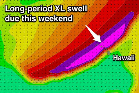 As talked about last update, into this coming weekend we're due to see a XL swell impacting the North Shore.
Currently an intense low spawning off Hokkaido, Japan, will intensify significantly south-east of the Kamchatka Peninsula, producing an initial broad fetch of severe-gale W/NW winds in our far swell window. This will produce an active sea state for a secondary push of the low towards us as core winds reach storm-force.
A large, powerful and consistent NW veering N/NW groundswell will be generated for this weekend, building rapidly late Saturday to the 12-15ft range ahead of a peak overnight/early Sunday in the vicinity of 15-18ft, with larger sets at deepwater offshore reefs.
Weaker E/NE trades are expected over the peak of the swell, but have another check back here on Thursday for an update on how this swell is tracking.
Comments
Bombs away craig !
How about the swell a few days behind it !!
Yep there's another one a few days later right in the Pipe swell window, later Tuesday and Wednesday morning.
America gets a lot of swell there this lot
The Peahi challenge is on yellow alert. With light winds forecasted that could be their window for Sunday morning?? Also with the WSL gear in Maui they will keen to stage the event. But there could be bigger days with this El Nino year!! Feel the pressure on the Commissioner Peter Mel.