Large pumping Friday, bigger later Sunday/Monday with poor winds

Hawaii North Shore forecast by Craig Brokensha (issued Wed 17th December)
Best Days: Tomorrow morning, later Thursday for experienced surfers through until Saturday morning, Sunday morning
 This week and Saturday (Dec 19 - 20)
It's been a slow couple of days on the North Shore but we've got a lot more energy on the way for the coming forecast period. A small increase in NW groundswell is due through today, holding into tomorrow at an inconsistent 3-5ft across the North Shore.
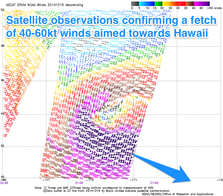
Of much greater importance is a large and powerful NW groundswell arriving later in the day and peaking Friday morning. The source of this swell was a very intense low pressure system positioned north-west of the islands, with satellite observations confirming a fetch of 40-60kt winds aimed towards Hawaii. This low has since weakened a touch while pushing further east but is still generating severe-gale to storm-force W/NW winds to our north aimed towards the US West Coast.
What should result is a large and powerful NW groundswell building rapidly to 6-8ft+ by dark tomorrow and peaking early Friday morning to 10-12ft at swell magnets and 8-10ft at Pipe. As the swell eases a slight swing in direction to the north is due later Friday and through Saturday from the 6ft range.
The only issue over this period is the local winds and strong E/NE trades are due tomorrow before easing a touch through Friday from a straighter E'ly direction. Saturday should then see fresh but easing E/SE winds and afternoon sea breezes.
 Sunday onwards (Dec 21 onwards)
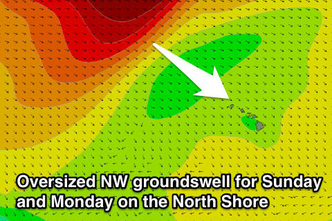
There hasn't been any real change to the oversized W/NW tending NW groundswell due across the North Shore through Sunday and Monday both size wise and local wind wise.
An intense and broad low 'bombed' off Japan and has aimed a dissected fetch of severe-gale to storm-force W/NW winds initially towards Hawaii. This low will travel slowly east over the coming days undergoing a couple of intensifications with bursts of severe-gale to storm-force W/NW winds continuing until the progression weakens to the north-northwest over the weekend.
What will result is an initial long-period and inconsistent W/NW groundswell arriving late Saturday, building overnight ahead of the much larger and more consistent NW groundswell through Sunday afternoon and evening.
Swell magnets should build from 8-10ft early to the very large 15-20ft by dark and then hold a similar size through Monday morning ahead of a very slight drop in size during the afternoon ahead of a more noticeable drop Tuesday and Wednesday. The slow easing trend is due to the secondary fetches of W/NW gales behind the primary large swell producing front.
Winds Sunday will be OK and freshen from the E/NE, but come Monday through Wednesday poor and strong N'ly breezes are due writing off the surf across the coast.
Into the end of the week we're only due to see easing amounts of swell with lingering winds from the N/NW which isn't ideal, so the coming few days will be the pick of the period.