Make the most of today

South Australian Forecast by Craig Brokensha (issued Friday May 13th)
Best Days: Today, Sunday afternoon South Coast, South Coast Tuesday and Wednesday
Features of the Forecast (tl;dr)
- Easing W/SW swell tomorrow with strengthening N/NE tending N/NW winds, W'ly mid-late PM
- Building windswell on the Mid later tomorrow
- Moderate sized, localised W/SW-SW swell Sun with moderate W/SW-W/NW tending fresh N/NW winds
- Building W windswell Mon with strong N/NW tending NW then W/NW winds
- Large W/SW groundswell later Monday but more so Tue with fresh W-W/NW winds
- Easing swell Wed with gusty N/NE winds
Recap
Our new large W/SW groundswell started to show yesterday morning across the Mid Coast with 1-2ft sets and a slight bit of imperfection from northerly winds. More size showed into the afternoon but the large high tide swallowed it up as winds went variable.
This morning is a different story with pumping 3ft sets under a light offshore breeze and options all over. The South Coast is slower and not getting much of the westerly swell energy, blocked by Kangaroo Island.
Winds will tend variable into the afternoon with the swell set to slowly ease but the incoming tide will help buffer this inside the gulf.

Pumping surf today
This weekend and next week (Jun 13 - 20)
Today’s pumping W/SW groundswell will ease into the weekend with winds expected to strengthen from the N/NE tending N/NW winds, W’ly mid-late afternoon.
The South Coast looks to ease back from 2ft+ across Middleton tomorrow with easing 2ft sets across the Mid Coast, though with building windswell through the afternoon.
The strengthening winds will be head of a weak mid-latitude low moving in from the west. This low will strengthen while moving across us, bringing strong W/SW winds but a low-period, weak swell for Sunday to 2ft+ across the Mid Coast and 3ft or so across Middleton.
Conditions will improve through the day down South on Sunday with W/NW tending freshening N/NW winds ahead of the next mid-latitude low, with this secondary system due to be much stronger.
Winds will strengthen more from the NW into Monday ahead of a stronger and better swell producing mid-latitude low.
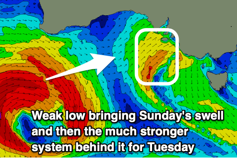
Compared to the low linked to today’s strong swell, this coming system will form a little more south and push closer towards us, with it forming south-west of Western Australia today.
It’ll be strongest in its earlier stages, with a fetch of severe-gale to storm-force W’ly winds due to be projected through our western swell window, weakening on approach through the weekend but still maintaining a fetch of strong to gale-force winds.
Another large, consistent W/SW groundswell is due with it expected to arrive later Monday but peak through Tuesday.
This swell looks larger than the current swell and should peak to a strong 3-4ft across the Mid Coast with Middleton coming in at 6ft or so thanks to the better aligned incoming fetch.
Local winds on Monday will strengthen from the N/NW tending NW and then W/NW as the low approaches us, kicking up stormy levels of windswell with Tuesday likely to see gusty but easing W/NW winds.
Wednesday will be cleaner as the low clears and swell eases with fresh N/NE winds due to favour the South Coast. We’ll confirm this and the expected sizes on Monday.
Longer term, as touched on in the last update, we’ve got a good flurry of Southern Ocean storm activity developing south-west of Western Australia next week, generating good, increasing levels of W/SW groundswell from later next week but more so the weekend. More on this in Monday’s update. Have a great weekend!
Comments
Every time I’m away working it’s pumping