Easing weekend of surf with a better westerly swell Tuesday

Victorian Forecast by Craig Brokensha (issued Friday May 13th)
Best Days: Today (afternoon to the east), Tuesday Surf Coast, Wednesday Surf Coast
Features of the Forecast (tl;dr)
- Easing W/SW groundswell tomorrow with strengthening N winds (fresh N/NW in the AM to the west, possibly N/NE later to the east)
- Smaller to tiny Sun AM with strengthening N/NE-N tending N/NW winds
- Small mix of mid-period W/SW and SW swell building Sun AM, easing Mon
- Strong N winds Mon
- Moderate to large sized W/SW groundswell Tue with strong N/NW tending NW winds
- Easing swell Wed with strong NW tending N/NW winds
- Smaller Thu with N-N/NW winds
Recap
Wednesday's inconsistent SW groundswell eased off into yesterday but the Surf Coast held a fun 3ft most of the day with lighter winds developing to the east, providing fun waves into the afternoon on the high tide.
Today, our inconsistent and tricky W/SW groundswell is slow and only coming in at a similar 3ft+ or so across the Surf Coast magnets with 4-5ft sets to the east. Conditions are again clean with fun options on the Surf Coast, improving to the east again into the afternoon as winds go more variable.
The swell is due to start easing through the day so the most energy will likely be found this morning.
This weekend and next week (Jun 13 - 20)
We’ve got easing surf over the weekend with strengthening N’ly winds as a small mid-latitude low pushes east through the Bight. Winds look fresh N/NW through the morning, shifting more N’ly and then possibly N/NE later to the east, but most of the day is likely to be wind affected to the east.
Easing sets from 2ft+ are likely on the Surf Coast tomorrow with 3-4ft waves to the east, smaller Sunday morning strengthening N/NE-N tending N/NW winds.
Into the late afternoon Sunday, a mix of smallish mid-period W/SW and SW swells are due, with the westerly energy having no real size, generated by the northward located low moving through the Bight.
The SW energy will be generated by a weak front passing south of Western Australia today and both aren’t really expected to top 2ft on the Surf Coast with 3ft to possibly 4ft on the Mornington Peninsula later Sunday, easing from a similar size Monday.
Winds will strengthen more from the N’th into Monday ahead of a stronger and better swell producing mid-latitude low.
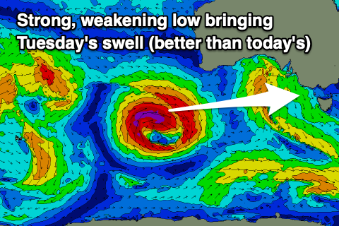
Compared to the low linked to today’s underwhelming swell, this coming system will form a little more south and push closer towards us, with it forming south-west of Western Australia today.
It’ll be strongest in its earlier stages, with a fetch of severe-gale to storm-force W’ly winds due to be projected through our western swell window, weakening on approach through the weekend but still maintaining a fetch of strong to gale-force winds while projecting a little less favourably north.
A moderate to large W’ly groundswell should arrive early Tuesday and peak through the day to 4-5ft on the Surf Coast with 8ft sets on the Mornington Peninsula and with strong N/NW tending NW winds.
The remnants of the low will move north of us through Tuesday/Wednesday, with easing levels of swell into Wednesday with strong NW tending N/NW winds.
Longer term, as touched on in the last update, we’ve got a good flurry of Southern Ocean storm activity developing south-west of Western Australia next week, generating good, increasing levels of W/SW groundswell from later next week but more so the weekend. At this stage the size looks to peak Sunday but more on this in Monday’s update. Have a great weekend!
Comments
It was certainly slowwww out there this morning, very gentle swell that did very little to warm me up in the near 0 degree air temps.
It's a shame all the swells are coming in unders this week, conditions have been nice otherwise. Next week's easy 6ft now also looking unlikely. Assume it's the westerly direction causing all that Craigos?
Yep and that progression was expected to push in closer and stay a bit more south but now it's more west and shifting a little north across us.
I'm being a little cautious but I feel there could still be some 6ft sets there. Let's reassess Monday.
All good, thanks mate
Craigos, calling 3+ on surfcoast magnets this morning is a crime. 2 foot max. No disrepect to the king, but calling a spade a spade here. Lovely morning though, had a very fun surf!
Ah bummer, saw some nice sets at Bells/Winki.
Almost sounded like a bit of disrespect directed at the king.
Haha agree. If there were 3fters I sure as shit wasn't on them.
I hate myself for even hinting that the Lord himself has missed this week.
T-Bird/Dx - easy boys!!
You'll be smited for undermining holy Craigos
Enjoy hades brothers
Watch your mouth tubbabird
Easy boys! I'm the first here to wish Craigos a Merry Christmas and praise his forecasts, in my eyes he is the GOAT of GOATs.
It wasn't a question of his forecast abilities either if you read my comment, I was speaking directly to the observation of swell size on the Friday morning 'coming in at a similar 3ft+ or so across the Surf Coast magnets', because I was at bells at 7.15am on Friday morning it was 2 foot max from my observation.
Saw plenty this size this AM.. Tubba's spent too much time in Hawaii ;p
But nothing like the 4ft I forecast, so criticism is warranted.
no criticism warranted - as you went above and beyond to provide us with that update yesterday, which downgraded the forecast.
It was a nice day to sit in the line up and take in the sun, while picking off a small wave here and there.
No criticism Craigos, just a difference in observation is swell size. "If everyone is thinking alike, then somebody isn't thinking." — George S. Patton
I think it is a bit unfair to complain if the swell is a foot smaller (or bigger) than forecast considering the complexities involved. The conditions have been good the last few days, so we just have to make the most of what's on offer. Hopefully the next three or four days deliver a bit more of what we want.
I think it’s totally rude altogether to criticise someone or organisation who are working on models of predictions rather than exactness.
The amount of time and effort to format a forecast for spatial and temporal predictions, coupled with swell period analysis would not be easy.
The minute amount of coin we pay as a subscription, well, find me a deal on anything that comes close to that for value.
If the vagaries of Craig’s predictions do your head in, go back to the days in the late 70’s where you quickly got a newspaper, flicked to the weather page to find a black and white synoptic chart and ascertain how close millibars were together to get an idea of that low pressure system, look for the highs and then guess wind direction and all the other variables.
Like today’s instant gratification society, we want it now, if that’s the case, do it yourselves.
And, for those who say i pay my subscription, my local camera needs a clean or whatever, just listen to yourselves once in a while, it’s all about me, me, me, me and me, Fair dinkum. AW
Mate… it’s a bit of light banter if you read the above without taking yourself too seriously. Craig rightly gets plenty of kudos on these forecast notes, he’s a legend, and this website is bloody great.
Swell has come in unders this week, it happens. Reckon you can lighten up a bit.
Reckon you should light one up and chill.
At no stage did I intimate criticism toward anyone. I’m entitled to my opinion.
You’ve got one and so have I.
There’s a long history of folk on here whinging on all manner of trivial matters regarding forecasts and cameras.
Obviously young crew who couldn’t read a weather map if their life depended upon it.
As a surfer, surely it’s up to yourself and your inherent knowledge to be able to ascertain what the surf’s doing.
What are you going to do if you have no forecasters , panic and not go surfing.
Again, my opinion, it wasn’t aimed at you or anyone.
I remember you, we banged heads a few years ago over some similar stupid comment you posted when The WSL went to Rottnest Island. Nothings changed it appears.
Opinion and criticism are two entirely different issues, maybe you need a lexicon. AW
Haha I can comfortably say mate without a shadow of a doubt I’ve never said a single word about anything related to Rottnest Island and the WSL, so likely mistaken identity there. Wouldn’t have even known the tour went there, I don’t really follow it much.
My comment back to you on here was purely that it was just a few guys having a joke with our regular forecaster who certainly in my eyes and many many others on here is highly respected for his craft. He goes over and above.
Anyway, I genuinely like your contributions on here so I’m moving on. Hope you score a few when the swell kicks next.
Dx3. Hi mate.
I sincerely apologise to you for my brash comments.
The older I get, the more intolerant I’ve become, especially with a society reliant upon phones and computers.
And, witnessing students failing and falling way behind in life just because they hold a gadget in their hand 24/7.
Again just my opinion
We did very well without them.
All the best to you and I’ll try to be more sensitive towards others views, I hope. AW
Sounds like you're shadow boxing a bit here AW, but I appreciate the sentiment
Monsieur poopy. Hi .
As you can see by my comment, I’m no ‘Angels ‘ and definitely not a shadow boxer.
Reiteration- surf forecasters cannot be 100% on the money all the time, way too many variables.
Appreciate your feedback and apologise if I came across a bit gruff.
I’m just not tolerant of the instant gratification society we live in. Period. AW