Large swells due to impact Hawaii from Sunday

Hawaii North Shore forecast by Craig Brokensha (issued Wed 3rd December)
This week and weekend (Dec 4– 7)
Yesterday's solid pulse of W/NW groundswell to 6-8ft+ across the North Shore eased back from the 6ft+ range this morning, but an underlying NE groundswell became more evident, generated by a stalling mid-latitude low to our north-east, half way to California.
This swell is keeping solid 6-8ft sets hitting the North Shore under offshore E/NE trades.
The low responsible for the current NE swell weakened and moved out of our swell window yesterday and with this we'll see the swell back off through tomorrow, from 5-6ft during the morning, down further through Friday.
A new N/NW groundswell is due to build through Friday and peak in into the afternoon, generated by a fetch of NW gales projecting down towards us from the Aleutians the last two days.
The front is currently just north of Hawaii and will project one final fetch of strong N/NW winds towards us today, helping to increase the consistency and longevity of the N/NW swell into Saturday morning.
We should see most reefs building to 6-8ft during Friday afternoon before backing off slowly from the 6ft+ range Saturday morning.
Winds will swing a little less favourable from the NE through Friday afternoon and Saturday before reverting back to the E/NE through the day Sunday.
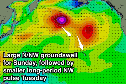
Later Saturday we should see the long-period fore-runners of a large N/NW groundswell due Sunday fill in, generated by a very strong frontal system pushing off the Aleutians, right down towards Hawaii during the coming few days.
A fetch of gale to severe-gale NW winds will be projected towards the North Shore, producing a large N/NW groundswell peaking Sunday morning to 12ft+. Later Saturday a kick to 6-8ft is expected, and the swell should ease through Sunday afternoon and further into Monday, the start of the Pipe Masters, from the 8ft range.
Next Monday onwards (Dec 8 onwards)
While Sunday's N/NW groundswell will back off through Monday, a new long-period and strong NW groundswell is due to fill in late in the day, peaking through the day Tuesday.
The source of this swell will be a really strong Aleutian Low, generating a fetch of severe-gale to storm-force W/NW winds through Hawaii's far swell window, not really pushing down as close as the previous systems.
Still the strong core wind speeds will generate a large long-period NW groundswell arriving in the 20s range and peak Tuesday to 8ft+.
 Before this swell even gets a chance to ease though, a much larger NW groundswell event is due to supersede it through Wednesday and then Thursday.
This will be related to a strong node (peak) of the Long Wave Trough focussed over the North Pacific setting in motion a series of broad and vigorous cold fronts around a near stationary Aleutian Low centred north of Hawaii.
The best thing about this progression is that we'll see each front acting on the active sea state created by the front before it, which makes it easier for a larger open ocean swell to develop as the secondary fronts need to do less work.
At this stage the sizes and timings are still fluid, but we should see the North Shore easily hitting the 15ft+ range through Wednesday afternoon and Thursday, but we'll look at this closer in the next update on Tuesday.
Winds through early next week will also go funky and variable from the S'th due to the close proximity of the storms pushing down towards Hawaii. Still we're not expecting strong Kona (southerly) winds, which would spoil the North Shore, and fresh E/NE trades should kick in again by Wednesday afternoon.