Action packed forecast

Eastern Tasmanian Surf Forecast by Craig Brokensha (issued Friday March 4th)
Best Days: Saturday, Sunday protected spots, Monday afternoon and evening, Tuesday morning
Features of the Forecast (tl;dr)
- Large, easing E/NE-NE swell tomorrow with variable winds, smaller Sun with strong S/SW-S tending S/SE winds
- Building S/SE windswell Sun PM, easing Mon with fresh E/SE-SE winds, abating into the PM
- Inconsistent E/NE groundswell building later Sun, holding Mon, easing Tue
- E/SE swell building late Mon, easing Tue with W/SW tending strong S winds
- Likely new SE-E/SE swell later nextweek
Recap
A large pulse of NE groundswell through yesterday afternoon but with onshore winds, cleaner this morning with a variable offshore and large sets continuing in the 6-8ft range.
This weekend and next week (Mar 5 - 11)
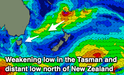
The slow moving Easterly Trough Low that's been bringing the flooding and large surf for much of the East Coast is now weakening in the Tasman Sea and we'll see a slow downwards trend in size from the E/NE-NE direction over the weekend.
Winds tomorrow will be variable with lumpy, clean surf easing from the 6ft range across open beaches with sea breezes due to be weak and variable also, keeping conditions decent all day.
 A surface trough and deepening low will bring a strong S/SW-S change Sunday morning along with a rapid spike in S/SE swell through the day as winds shift S/SE.
The E/NE swell should still be 3-4ft inside southern corners, and there'll also be some inconsistent E/NE groundswell building through the late afternoon, peaking Monday morning. This is being generated by a strong stalling low that's developed north of New Zealand and should maintain infrequent 3-4ft sets into Sunday evening and Monday morning.
The S/SE windswell looks to build to 3ft to maybe 4ft Sunday afternoon, while a broader fetch of E/SE winds setting up between New Zealand and the mainland looks to generate some reinforcing E/SE swell for later Monday and Tuesday, maintaining 3-4ft surf.
Winds will unfortunately be onshore out of the E/SE-SE on Monday though weakening through the afternoon and offshore Tuesday morning from the W/SW ahead of another trough and S'ly change.
We may see another low forming in trough line on Wednesday, generating some localised S/SE-SE swell later next week but more on this Monday. Have a great weekend!