Plenty of swell though dicey winds

Eastern Tasmania Surf Forecast by Craig Brokensha (issued Monday 15th March)
Best Days: Desperate surfers tomorrow afternoon on the south magnets, possibly dawn Wednesday on the south magnets
Features of the Forecast (tl;dr)
- Building S groundswell tomorrow with S/SW tending E/SE winds, easing Wed with E/NE winds, possible variable early
- Building, weak E/NE tending E swell from Thu, further on the weekend but with persistent E/NE winds
Recap
Good 3-4ft sets out of the N/NE on Saturday with improving conditions late as the swell started to ease and a change moved through, clean yesterday morning but back to a small 2ft, tiny today.
This week and next (Mar 16 - 26)
 There's a bit of swell on the cards for the coming period, firstly from the south and then out of the east.
Currently a strong polar low is projecting a fetch of weakening gale to severe-gale W/SW tending SW winds through our southern swell window, bringing a S'ly change this afternoon.
The swell will build through tomorrow, reaching 4-5ft across the south swell magnets into the afternoon but with S/SW tending SE and then E/SE breeze. This won't be ideal and Wednesday looks a touch better with variable tending E/NE winds as the swell eases from 2-3ft or so.
As the S'ly swell eases, we'll then be looking at a slow increase in E/NE-NE swell as a high sits in the Tasman Sea, squeezed on its northern flank by instability in the Coral Sea and also from the north-west by a deepening inland surface trough.
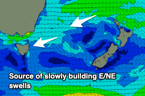 We should see persistent E'ly winds generated just within our swell window, producing small, weak levels of E/NE tending E swell from Thursday through next week, starting out around 2ft but strengthening into the afternoon and building more to 3ft or so.
Depending on which way the models go we may see a surface depression aiming stronger E/NE winds down towards us into early next week, producing more size, but we'll have to review this over the coming updates.
Unfortunately with this setup we'll be seeing persistent onshore E/NE-NE winds, possibly lighter at times but for the most part average. Therefore get ready for a run of peaky, onshore, grovelly surf.