Southerly swells to kick off autumn

Eastern Tasmania Surf Forecast by Craig Brokensha (issued Monday 1st March)
Best Days: Protected spots tomorrow, Wednesday, protected spots late Friday, Saturday morning, Sunday
Features of the Forecast (tl;dr)
- Rapid increase in S swell tomorrow with SW tending S winds, easing Wed with W tending NE winds
- New S'ly swell building Fri, strongest late, then easing slowly Sat, further Sun with the cleanest conditions
Recap
As expected the swell seen Friday morning was all but gone into Saturday and the S'ly swell too weak to provide any real action. Yesterday a small S'ly swell provided a touch more action, though mostly tiny surf, similar today.
This week and weekend (Mar 2 - 7)
After the recent weeks of north-east swell energy, we've now got an active southerly swell window with a broad, slow moving node of the Long Wave Trough due to strengthen over the Tasman Sea this week.
We'll see fronts strengthen and steered up past us, with the first this evening followed by a broader, more elongated system on Thursday and Friday.
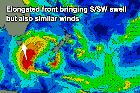 This evening's has been upgraded since last week, with a fetch of S/SW gales developing adjacent our coast early tomorrow, producing a rapid spike in S'ly swell through the day, kicking to 4-5ft+ across the south magnets but with strong SW tending S/SW-S winds. Try southern corners for the best waves.
Wednesday will see light W'ly winds ahead of NE sea breezes as the low quickly moves off to the east.
This will also result in a rapid drop in size with easing 3-4ft sets on the south magnets, tiny Thursday.
Now moving into Thursday we'll see a broad though initially unfavourably aligned fetch of strong SW winds pushing up past us, strengthen and tending more S/SW in our southern swell window Friday.
This should produce a building mid-period S'ly swell for Friday morning, with stronger groundswell energy arriving late in the day but most likely peaking early Saturday morning.
Size wise we should see the swell peaking around 4-6ft late Friday and early Saturday though with strong S/SE winds on the former and SW tending E winds on the latter.
Sunday looks the cleanest with easing 3-4ft sets and NW tending NE winds.
Beyond this run of S'ly swell there's nothing significant on the cards so try and make the most of it!
Comments
Are these estimates likely true for most the east coast? I thought that a straight south swell like that predicted will maybe fly right by the east coast and miss it entirely? Friendly hint in the right direction would be greatly appreciated. Thanks
Not most of the East Coast but for northern ends of beaches that aren't blocked by headlands to the south and more exposed, south facing breaks.
Expect the southern ends of beaches to be much smaller and even flat in some instances if totally blocked by headlands etc.
Google maps is your friend in starting to figure out where will and won't get swell.
When storms are so broad and strong, even though not perfectly aimed the swell radially spreads back into the coast, much like dropping a pebble and seeing the ripples spread out across a pond.
Thanks a lot! That’s very helpful.
Generally I wouldn't bother with anything over 180 degrees. See how todays swell compares to Fridays swell - it'll be vastly different I reckon.
Is fridays swell supposed to be more than 180 degrees or today’s swell?
The next swell is better aligned and not from a more local source. Looked like a nice kick yesty though.
Thanks!
They are east coast forecast notes.
Once the fetch / low gets clear of the coast the swell will start to build and refract back in.
Depending on the coastal aspect you'll got different sizes and surface conditions.
Read the notes (learn weather chart basics), go get your own observations, repeat - a lot!
Thank you!
Thanks Belly as well.