North-east swell to continue until late next week

Eastern Tasmania Surf Forecast by Craig Brokensha (issued Friday 19th February)
Best Days: Saturday, Sunday, Monday morning, Tuesday morning, Wednesday, Thursday in southern corners
Features of the Forecast (tl;dr)
- Easing N/NE windswell Sat with N/NW winds ahead of a evening S'ly change, smaller Sun AM with similar winds
- NE trade-swell pulse for Sun PM, easing slowly Mon ahead of E/NE groundswell Tue, holding Wed, easing Thu
Recap
Building N/NE windswell yesterday, peaking through today to 3-4ft but with less than ideal winds.
This weekend and next week (Feb 20 - 26)
The current N/NE swell will ease through tomorrow as the squeezing of pressure between a south-east tracking low from the Bight and high in the Tasman relax. This will see winds ease locally, and the swell dropping from the 3ft range.
Conditions will improve with a local, morning N/NW breeze, light, possibly freshening through the day ahead of an evening S'ly change.
This will be as a weak trough pushes through, so weak that winds on Sunday will revert back to the N/NW, holding ahead of another evening S/SE change.
We'll be in between swells in the morning with the size easing back from 2ft to or so.
 Into the afternoon though some new NE trade-swell is expected, produced by a good burst of strong E/NE winds, on top an active sea state, down towards us today from the northern Tasman Sea.
Inconsistent sets should build through Sunday afternoon, reaching 3ft to occasionally 4ft and with more punch and power. The swell might ease back a touch Monday from the inconsistent 3ft range ahead of our E/NE groundswell on Tuesday.
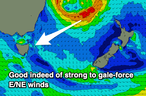
The tropical low linked to this groundswell will form adjacent the Qld coast early Sunday and drift south fairly rapidly. This rapid southward movement isn't ideal but we'll see a good fetch of strong to gale-force E/NE winds aimed through our swell window from Sunday through early Monday.
This longevity of the fetch will prolong the swell, with the first increase in size due through Tuesday, offering inconsistent but good 4-5ft sets through the day, while Wednesday looks to come more around 3-5ft. Some spots will pick up the bulk of the energy while others will be smaller so be prepared to do a little searching.
Coming back to the local winds and conditions, Monday looks good with a morning W/SW offshore ahead of sea breezes. Tuesday will see fresher S/SW winds ahead of N/NE sea breezes and then freshening NW winds on Wednesday. A S/SE change is likely Thursday as the E/NE swell eases, but more on this Monday.
Longer term we may see some new NE swell late week, but we'll have a closer look at this Monday. Have a great weekend!