Small swells through the period

Southern Tasmania Surf Forecast by Craig Brokensha (issued Wednesday 10th February)
Best Days: Beginners tomorrow and Friday, exposed breaks Friday for the savvy, Tuesday through Thursday
Features of the Forecast (tl;dr)
- Tiny, clean beginner waves Thu AM
- Inconsistent E/SE groundswell Fri, best across exposed breaks with NW tending W/NW winds
- Building W/SW groundswell Sun PM but with S/SE sea breezes, easing Mon with S/SE tending E/NE winds
- Better W/SW swell for Wed with N/NE tending E/NE winds
Recap
Onshore surf yesterday, cleaner and better today with fun 1-2ft sets.
This week and next (Feb 11 - 19)
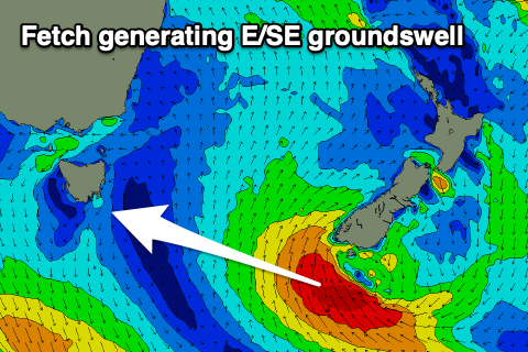 This morning's swell will fade tomorrow with tiny waves for beginner under a N tending strong NE breeze, while out inconsistent E/SE groundswell for Friday is on track. This swell is being generated today by a strong low forming off the south of New Zealand's South Island. A good fetch of SE gales should produce a small 2ft wave across exposed breaks down the arm, smaller in Clifton and to 1ft or so.
Winds should swing from a dawn N/NW breeze to the NW and then W/NW into the afternoon, favouring these breaks.
Saturday will see the E/SE groundswell fading and a weak front pushing in from the west doesn't look favourable at all for generating any decent swell.
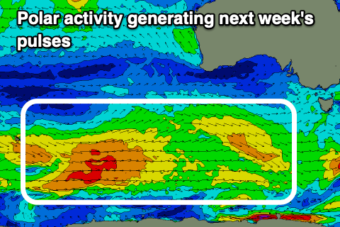
Looking further afield and a good, broad and elongated though not overly strong frontal progression will push in from the Heard Island region through this week and weekend. This will bring inconsistent but persistent pulses of small swell, with the size mostly coming in around 1-2ft across Clifton, nothing too substantial.
Today the strongest but most distant of the fronts is generating a fetch of W/SW gales south-west of WA and the swell from this should arrive Sunday afternoon and kick late 2ft on the sets across Clifton.
 Weaker fetches of strong to near gale-force W/NW-W/SW winds will produce reinforcing pulses, with the best due later Tuesday and more so Wednesday, back to 2ft. In between Monday and Tuesday look to hover around 1-2ft.
Local conditions will be favourable from Tuesday, with Sunday afternoon seeing S/SE sea breezes, lingering out of the S/SE Monday morning but shifting E/NE into the afternoon. Offshore N/NE tending NE winds are then expected Tuesday, similar Wednesday and Thursday while strengthening.
The surf will fade into the end of the week and then there's nothing much to talk about in the longer term as the storm track fires up towards Western Australia, too north and west of us. More on this Friday.