Get stuck into the coming south swell

Eastern Tasmania Surf Forecast by Craig Brokensha (issued Friday 15th January)
Best Days: South swell magnets Sunday, Monday, Tuesday morning, Wednesday, Thursday morning
Features of the Forecast (tl;dr)
Small N/NE windswell tomorrow with variable N-NW winds ahead of a strong, late morning S/SE change
Recap
Tiny waves yesterday morning but the expected kick in N/NE swell eventuated with 2ft sets showing, though with an onshore breeze. This morning it's faded back to a tiny 1-1.5ft.
This weekend and next week (Jan 16 - 22)
Looking at the coming weekend and there isn't expected to be any surf tomorrow, with a fetch of local S/SW winds showing a spike in S'ly energy on the charts but it'll be too weak and aimed away from us.
Into Saturday afternoon and evening we should see a good polar front, the first in a series falling under the influence of a strong node of the Long Wave Trough, pushing up past the south-east corner of the state, generating a fetch of strong to sub-gale-force SW winds.
A mid-period S'ly swell should be seen Sunday morning from this source, offering 2-3ft waves across south facing beaches, easing through the day along with W/NW tending variable winds.
A secondary though more zonal front pushing across us Sunday doesn't look as favourable for swell production on Monday with small 2ft to possibly 3ft waves due on the south swell magnets, flat elsewhere. Conditions will remain clean again though with a freshening W/NW breeze.
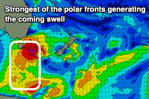 Now, the best and strongest polar front is due to push up and past us Monday evening and early Tuesday, with a broad fetch of severe-gale SW winds followed by weaker S/SW winds extending to the polar shelf.
A moderate to large though short-lived pulse of S'ly groundswell should be seen from this front on Tuesday morning with 4-5ft+ surf due across the south swell magnets (much smaller elsewhere), more so across the northern half of the coast, easing through the day and with W/SW tending SE winds.
The easing trend will be slowed owing to the drawn out polar fetch, with winds swinging back offshore Wednesday from the W/NW tending NE as the swell eases from 4ft on the south swell magnets, 3ft on Thursday.
Weaker, trailing frontal activity may keep 1-2ft waves hitting the south magnets into the end of the week, but we'll have a closer look at this on Monday. Have a great weekend!