Small from the south and better from the north

Eastern Tasmania Surf Forecast by Craig Brokensha (issued Monday 28th October)
Best Days: South magnets tomorrow, Saturday
Recap
Nothing of note over the weekend, but a fun pulse of S'ly swell should of filled in across the coast today.
This week and weekend (Oct 29 – Nov 3)
It's good to be back, and looking at the coming period it looks like today's S'ly swell should be reinforced by a secondary pulse tomorrow before fading into Wednesday.
The source of this secondary swell was a polar fetch of off axis gale-force SW winds in our southern swell window, with south magnets expected to persist at 2ft to possibly 3ft tomorrow, easing from 1-2ft Wednesday morning.
 Winds will be great tomorrow and N/NW tending NW through the day, poor Wednesday in the wake of a trough and with S/SE tending E and NE winds.
Following this our attention turns to the weekend and a good pulse of N/NE windswell.
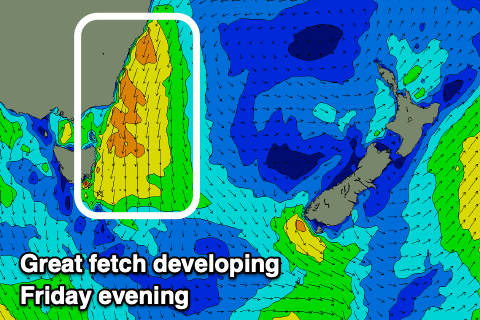
A strong high sitting in the Tasman Sea will be squeezed by mid-latitude fronts pushing in from the Bight, though weakening on approach across our state.
This will see a great fetch of strong to near gale-force N/NE winds generated from the southern NSW coast down to us Friday afternoon and evening, pushing away through Saturday.
This should kick up a good pulse of N/NE swell for Saturday, coming in at 3ft with N/NW-NW winds as one of the fronts pushes across us.
Sunday will be clean again with with small, easing 1-2ft sets, fading through the day.
Onwards from this there's nothing too major on the cards, but we'll have another look Wednesday.