Couple of fun swells ahead

Eastern Tasmania Surf Forecast by Ben Matson (issued Wednesday 23rd October)
Best Days: Fri: building N'ly windswells with a mid-late morning W'ly change, providing a brief window of fun waves around lunchtime. Sun/Mon: strong S'ly swells.
Recap: Small S’ly swells have persisted at south swell magnets. It’s been clean with light winds.
This week (Oct 24 - 25)
The publish time of these Forecaster Notes will be erratic this week, as Craig’s on annual leave. To receive an email when they go live, please edit your user settings here: www.swellnet.com/user
Small residual S’ly swells will persist for the next few days though no major size is expected.
Thursday will be clean on the surface early, before N’ly winds freshen into the afternoon.
Friday looks very promising though. A pre-frontal N’ly airstream will reach 30kts overnight and into the early hours of the morning, generating 3ft of peaky N/NE windswell running sideways down the coast. Initially, winds will be N’ly at dawn but we’ll see a NW then W’ly wind shift through the morning, cleaning up conditions rapidly.
The swell won’t last very long though, so it’ll be important to capitalise on the couple of hours following the wind change - by mid-late afternoon we could be back to 1.5ft leftovers. So, keep a close eye on local winds, and pounce on your favourite NE swell magnet once the wind swings.
This weekend (Oct 26 - 27)
A strong passage of fronts and lows across Tasmania over the weekend will maintain westerly quadrant gales from Friday through Monday or even Tuesday.
However, all of the initial developments on Friday will be outside of our swell window(s), so Saturday will see very small and clean though wind affected conditions.
Fortunately, Sunday looks much better.
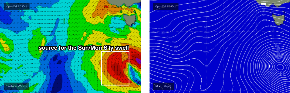
A deepening polar low well south of the state overnight Friday and into Saturday (see below) is expected to display a long, broad fetch of gale force S’ly winds and we’re looking at building S’ly swells into Sunday. Although the early stages of this low will develop just inside the Southern Tasmanian swell shadow, it will eventually move slowly eastwards into our swell window.
The acute direction will result in a wide range of wave heights on offer - starting off very small, but increasing from late morning or lunchtime onwards, and then reaching a peak around 3-5ft at exposed northern ends late afternoon, though it'll be significantly smaller at sheltered southern ends.
Conditions will however remain clean with fresh W/SW winds.
Next week (Oct 28 onwards)
Sunday’s strong S’ly swell will slowly ease through Monday, and winds are expected to veer W/NW as another front approached from the south-west. This should favour a quality morning in the 3-5ft range at exposed northern ends, though once again southern ends and protected spots will be much smaller.
Wave heights will then ease steadily throughout Tuesday (small but clean with NW winds, ideal for the open beaches), and the rest of the week is looking pretty small at this stage.
The next swell source looks to be a developing N’ly fetch off the the Southern NSW coast later next week, which could generate a N/NE swell for next weekend, but this is still quite some time away. More on this in Friday’s update!