Large E/SE groundswell for the weekend

Eastern Tasmania Surf Forecast by Craig Brokensha (issued Friday 11th October)
Best Days: Protected spots Sat AM, Sunday, Monday, Tuesday
Recap
A small pulse of S'ly swell yesterday with early offshore winds. Onshore today with a building SE swell late.
This week and weekend (Oct 12 - 18)
These notes will be brief as Ben's on annual leave.
We've got an upgrade in the E/SE groundswell due across the coast over the coming days with the low sitting off the tip of New Zealand's South Island coming in a little stronger than forecast by the models.
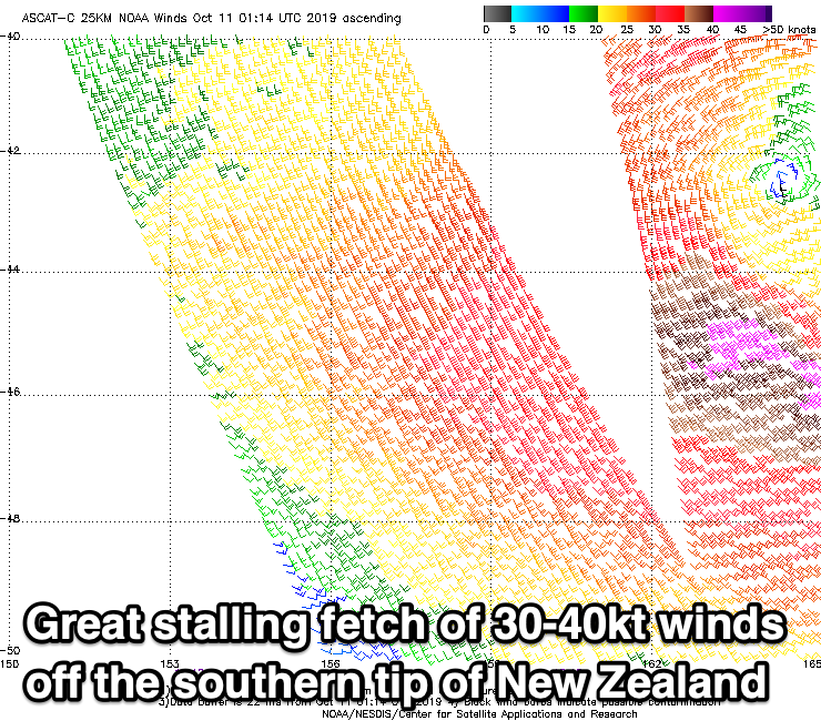
A great fetch of gale-force 30-40kt+ winds have been aimed through our swell window from yesterday afternoon through today, and will continue this evening before slowly weakening tomorrow, dissolving totally Sunday evening.
A large, prolonged E/SE groundswell will be seen, with the largest pulse filling in tomorrow, kicking to 6-8ft across most locations into the afternoon, then easing slowly from 6ft to possibly 8ft Sunday morning, down more noticeably Monday from 4-5ft, and 2ft+ Tuesday.
Winds are still an issue tomorrow and onshore from the SE, tending more E/SE into the afternoon. Try protected spots but take care.
Sunday looks cleaner with a light morning W'ly ahead of fresh NE sea breezes, W/NW tending gusty N/NE Monday and then W tending NE winds Tuesday.
Longer term there's nothing too significant on the cards so make the most of the coming E/SE swell event. Have a great weekend!