Lots of action from Thursday

Eastern Tasmania Surf Forecast by Craig Brokensha (issued Monday 27th May)
Best Days: Thursday afternoon, Friday morning, Saturday, Sunday morning south magnets, Tuesday morning
Recap
Tiny to flat conditions prevailed on the coast over the weekend and this morning.
Today’s Forecaster Notes are brought to you by Rip Curl
This week and weekend (May 28 – Jun 2)
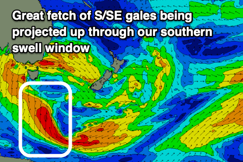
We near closer to the break in the mini swell drought, with the frontal activity that's currently impacting the western side of the state due to finally move into our swell window later week.
A broad and slow moving frontal progression will open up to us on Wednesday, with a polar fetch of S/SE gales on the southern flank due to be aimed ideally through our southern swell window, projecting north towards us Wednesday evening.
 A moderate to large sized S'ly groundswell will be generated by this fetch, building later Thursday and peaking Friday across the coast to 5-6ft across south facing beaches, smaller 3-4ft at other locations.
Ahead of this on Thursday morning though, the fetch of strong S/SW winds pushing up past us should produce a windswelly 3ft to maybe 4ft of swell for south magnets, with the groundswell larger and stronger late in the day.
Winds will improve and swing from the SW to the W on dark Thursday, so check south facing locations late in the day. Friday when the swell peaks looks a touch dicey with a fresh SW tending S/SW breeze, better from the W/SW on Saturday morning (N/NE into the afternoon) as the swell eases slowly from 4-5ft+.
A temporary low point in swell is due on Sunday, ahead of a new mid-period S'ly swell on Monday from another strong polar front pushing up past us. This will be with a fair bit of wind and likely to 4-5ft, cleaner as it eases Tuesday. More on this in Wednesday's update though.