Easing SE swell with follow up S swell

Eastern Tasmania Surf Forecast by Craig Brokensha (issued Friday 22nd Februay)
Best Days: Semi-protected spots tomorrow morning, possibly Sunday morning, northern corners Monday morning
Recap
Tiny surf yesterday and this morning but a new SE groundswell should of shown through the day. The cyclone swell probably won't impact as much as it didn't really perform well from Byron south.
Today’s Forecaster Notes are brought to you by Rip Curl
This weekend and next week (Feb 23 - 28)
With the cyclone swell from Oma likely not offering much in the way of surf we'll be looking at the SE groundswell due this afternoon easing in size from an inconsistent 2-3ft across south magnets. Conditions will unfortunately be poor though with a fresh S/SW tending S/SE breeze in the wake of a front moving up past the coast.
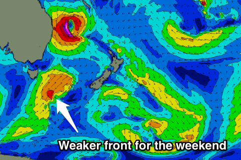 A fetch of strong to near gale-force S/SW winds will be projected up through our southern swell window, though not as strong as forecast on Wednesday.
A new increase in S'ly swell off this front should should come in at 3ft across south facing beaches on Sunday morning, easing slowly afterwards and down further from 2ft+ Monday.
Winds on Sunday don't like ideal and likely variable out of the SE, tending more NE through the day.
Monday will then be fun at south magnets with a fresh N/NW tending N/NE breeze.
Longer term there's nothing too significant on the cards for us besides a fun small N/NE windswell later week, but more on this Monday. Have a great weekend!