Dynamic, windy, active period

Eastern Tasmania Surf Forecast by Craig Brokensha (issued Monday 10th December)
Best Days: Late Sunday, Monday
Recap
Good fun levels of N/NE windswell all weekend with generally favourable conditions if you could work the winds, while today the swell has all but gone.
Today’s Forecaster Notes are brought to you by Rip Curl
This week and weekend (Dec 11 - 16)
The surf will remain tiny until late Wednesday but more so Thursday when we're expected to see a large and prolonged NE swell event though with onshore winds.
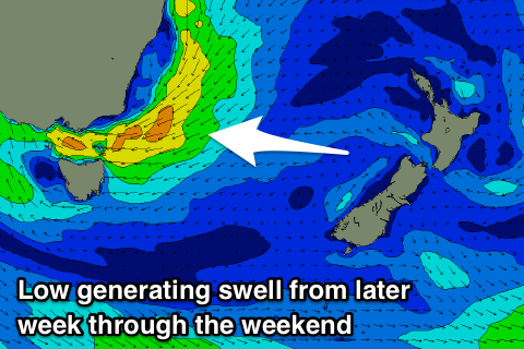
A deepening surface trough drifting in from the west is expected to form into a low pressure system and stall across NSW/Victoria through the end of the week.
The scope of the low is such that we'll see a broad and persistent fetch of strong NE winds aimed into us, possibly reaching the gale-force range out of the E/NE on Friday when the low reaches maximum intensity.
 We'll see a late kick in size Wednesday to 2ft or so, with Thursday building further 4ft+ but with strengthening NE tending E/NE winds.
Friday looks stormy and 3-5ft, while into the weekend we'll see the swell building back further as the NE fetch strengthens again in our swell window.
Size wise we're looking at surf to 5-6ft or so with poor E'ly tending E/NE winds, but we may see a N/NW change late in the day Sunday as the system dips south-southeast. Monday looks great early with a W'ly offshore ahead of a strong S/SW change and fun levels of easing swell.
The position, strength and movement of this low are still uncertain so check back here on Wednesday for a clearer idea on the outlook for the rest of the week and weekend.