Fun S/SE groundswell with NE swell next week

Eastern Tasmania Surf Forecast by Craig Brokensha (issued Wednesday 14th June)
Best Days: Thursday, Friday morning, late Sunday, Monday morning, Wednesday onwards
Recap
Nothing of note yesterday but today's S'ly swell has come in larger than expected with strong 4ft sets across magnets with offshore winds.
The swell should of eased off into this afternoon as offshore winds persisted.
This week and weekend (June 15 - 18)
Today's S'ly groundswell will be all but gone tomorrow, replaced by a strong new S/SE groundswell event.
It'll be a bit of a wait for the sets but exposed beaches should see 2-3ft sets, generated by a polar fetch of gale to storm-force SE winds south of New Zealand Sunday and Monday.
The swell is expected to ease back through Friday from 2ft+ and offshore winds from the W/NW are due through the whole period.
Saturday is expected to be small to tiny, but into Sunday and Monday we're looking at a quick spike in S'ly groundswell.
 A very intense low is forecast to pass under the state Saturday afternoon and evening, with a fetch of storm-force W/SW winds being generated on the edge of our southern swell window.
We should see some solid S'ly groundswell spreading up radially away from this fetch, filling in Sunday afternoon to 3-4ft at south magnets with a W/NW offshore.
The swell will drop away quickly Monday morning from 2ft to maybe 3ft early.
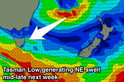
Of greater importance is a Tasman Low forming between the East Coast and New Zealand.
This low is forecast to be stationary through early to mid-next week, with some good NE swell spreading down into us from later Tuesday. This size is looking moderate in size but we'll have a closer look at this Friday.