Easing S/SE groundswell, smaller thereafter

Eastern Tasmania Surf Forecast by Craig Brokensha (issued Monday 22nd May)
Best Days: Tuesday, Wednesday morning north-east magnets
Recap
Building onshore waves out of the NE Saturday, pumping Sunday as winds went offshore and the swell peaked in the 5ft range (bigger at magnets).
Into the afternoon a new S/SE groundswell filled in and this has held 3-5ft this morning with offshore winds, creating another day of pumping surf.
This week and weekend (May 23 - 28)
The current S/SE groundswell event was created by a very strong polar outbreak south of New Zealand, with a new wave buoy situated in the Southern Ocean picking up a Maximum Wave Height of 19.4m.
 This swell has peaked and will continue to ease overnight, with easing 2-3ft sets due across south facing beaches tomorrow under offshore N/NW winds.
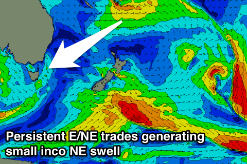
Some small NE swell should also be in the mix, generated by an infeed of NE winds into the the surface trough linked to the weekend's E/NE swell.
This only looks to come in at 2ft+ before easing Wednesday from a similar size.
For the rest of the week we'll see inconsistent levels of NE trade-swell from the Coral Sea impacting the state.
Currently a tropical low is squeezing a strong high sitting over New Zealand's North Island, directing a fetch of strong E/NE trades through our north-eastern swell window.
The low will deepen a little over the coming days, generating stronger winds before slipping away to the east and away from our swell window Wednesday.
With a travel time of 3 days, we'll see the swell slowly build Thursday reaching 1-2ft at north-east magnets, persisting Friday ahead of the strongest pulse Saturday to 2ft+ but with 10 minute waits for sets.
Conditions will be clean for the most part with offshore W/NW winds, more N/NW Saturday which is less than ideal.
Longer term there's nothing major on the cards, but have a check back here Wednesday for an update on this.