Dynamic week with lots of surf

Eastern Tasmania Surf Forecast by Craig Brokensha (issued Monday 15th May)
Best Days: Tuesday morning, Wednesday, Thursday morning, Friday morning south magnets, Sunday and Monday
Recap
Saturday's flukey NE swell looked to have hardly made an impact on the coast, and seeing the size on the southern NSW coast, this was a little expected.
Yesterday failed to offer too much in the way of surf, while some small E/NE and building SE swell provided 1-2ft waves this morning, increasing with onshores this afternoon.
This week and weekend (May 16 - 21)
We've got a very dynamic and tricky forecast period ahead.
Firstly a deepening and broad low directly north-east of us is projecting a great looking fetch of strong to gale-force NE tending E/NE winds through our eastern swell window as the low dips south-east. This fetch will move south and then weaken through tomorrow morning, resulting in a good pulse of E/NE groundswell, possibly showing late tomorrow, but more so overnight and peaking Wednesday morning.
Open beaches should see good 3-4ft sets, if not for the odd bigger one, easing back later in the day, down from 2-3ft Thursday out of the E.
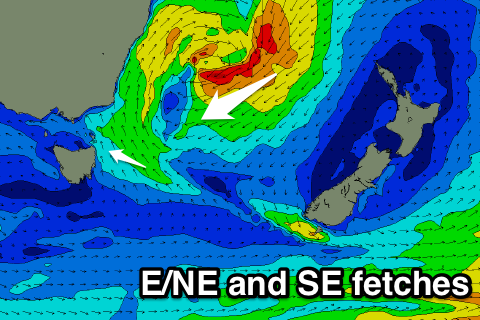 During tomorrow though some good SE swell should build, generated by the south-west flank of the low right off our coast. Strong SE winds will broaden tomorrow, with building surf from 2ft+ tomorrow morning, up to at least 3ft into the afternoon.
Conditions tomorrow should be clean with a morning W/SW offshore, swinging SE into the afternoon and then W/NW tending variable winds Wednesday with the stronger E/NE groundswell. Thursday morning should again be clean ahead of a shallow S/SE change.
This change is linked to a polar front pushing up and past us, with a good new S/SW groundswell due from it later in the day Thursday, but more so Friday.
The models seem to be overcooking the size a little for Friday morning, with south facing beaches more likely to come in around 3ft, easing through the day. NW tending NE winds will favour south magnets for this swell.
Now moving into the weekend and a deepening inland surface trough/low moving slowly in from the west will see a broadening and strengthening fetch of NE winds aimed into us over the weekend.
This should produce building levels of NE swell with NE winds Saturday, peaking Sunday morning as the trough moves east and swings winds offshore from the NW. We'll have to have a closer look at the developments surrounding this low, but also in the mix is likely to be some SE groundswell from an intense low south of New Zealand. More on this Wednesday.
Comments
Pumping!