Flukey north-east trade-swell, more potential next week

Eastern Tasmania Surf Forecast by Craig Brokensha (issued Friday 12th May)
Best Days: Saturday north-east swell magnets, Wednesday and Thursday
Recap
A small easing SE swell from 1-2ft yesterday morning, tiny into today
This weekend and next week (May 13 - 19)
The confidence regarding tomorrow's inconsistent NE trade-swell is down a little, with it coming in a little under forecast across the NSW coast.
With this I've adjusted the forecast back to an inconsistent 2ft at open beaches and southern corners tomorrow, with waits up to 10 minutes or so for sets.
Conditions will be clean though with a W'ly offshore, giving into a late S'ly change.
This change will be linked to a weak low forming off our coast, but it's not expected to generate much in the way of swell at all with weak S/SE winds aimed through our swell window Sunday through Tuesday.
 South facing beaches might see 2ft sets Monday and more so Tuesday but associated S'ly winds from the low will create average conditions.
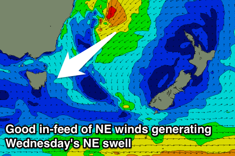
A better in-feed of stronger NE winds feeding into the eastern flank of the low should generate some better NE swell for Wednesday and Thursday.
At this stage we're looking at building levels of swell to 3ft+ through the afternoon, easing back from 3ft Thursday out of the E/NE as the low dips away to the south-east.
Morning SW winds are more than likely, but we'll confirm this Monday.
Longer term we may see some new S'ly groundswell later in the week, but of greater importance is a stronger and deeper low possibly forming to our east, generating that larger E/NE swell, but more on this Monday. Have a great weekend!