Fun Thursday, large stormy swell Monday

Eastern Tasmania Surf Forecast by Craig Brokensha (issued Wednesday 3rd May)
Best Days: Thursday south swell magnets, similar Saturday, protected southern corners Monday and Tuesday
Recap
Nothing of significance the last two days with tiny clean surf.
This week and weekend (May 4 - 7)
Tomorrow will be much better than today, with our more favourably aligned S'ly swell due to fill in. This was generated by a fetch of strong to gale-force S/SW winds projected up from below the state the last two days and should come in at 2-3ft across south swell magnets in the morning, easing through the afternoon and further from 1-2ft if we're lucky Friday.
Conditions will be great with a W/NW tending variable breeze tomorrow, increasing from the NW Friday.
 Into the weekend our flukey S/SE groundswell for Saturday is still on the cards, with a fetch of storm-force S/SE winds developing on the polar shelf, south of New Zealand today.
This fetch is small and distant, but we should hopefully see inconsistent 2ft sets at south swell magnets with a strengthening NW wind.
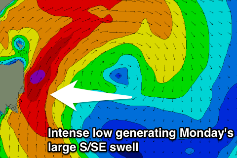
Of greater importance is the cold front moving across the state Saturday, developing into an intense and stalling low off us Sunday and Monday
This will see a fetch of strong to gale-force S/SE winds generated directly off and to the south-southeast of us late Sunday through Monday, producing a large stormy S/SE swell.
South facing beaches look to come in at 6-8ft Monday morning, easing off slowly through the day, with 4-5ft+ waves at open beaches.
Gusty S/SW winds will limit surfing options though, and we won't see winds really improve as the swell eases Tuesday due to the low weakening slowly while projecting north and not east, keeping S/SW winds blowing on the coast.
We'll have another look at this Friday though.