Tiny to small until mid-next week

Eastern Tasmania Surf Forecast by Craig Brokensha (issued Friday 28th April)
Best Days: No good days until later next week
Recap
A fun day of waves yesterday with an easing S/SE and E/NE swell coming in at 2-3ft with offshore tending variable winds.
Today though there was hardly any swell left at all with fading 1-1.5ft sets.
This weekend and next week (Apr 29 – May 5)
The weekend is't looking very promising in regards to getting a surf in on the East Coast.
A weak front pushing up past us tomorrow will only generate an average fetch of strong S/SW winds, with onshore 2ft windswell peaks likely at south facing beaches later tomorrow, fading from 1ft+ Sunday with offshores.
The South Arm will have better options, so maybe check out that forecast.
As talked about the last few updates, some better S'ly groundswell is due mid-week as a better aligned and stronger polar frontal progression pushes up and into the Tasman Sea.
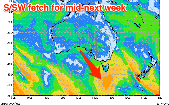 A broad fetch of strong to gale-force S/SW winds will be projected through our southern swell window Tuesday evening and Wednesday, kicking up a moderate sized S'ly swell for Wednesday afternoon.
This may be followed by a secondary polar front to our south-southeast, generating a secondary S'ly groundswell for Thursday afternoon and Friday morning, but we'll have to see how this plays out on Monday.
At this stage south facing beaches are due to build to 4-5ft later Wednesday with S/SW winds, easing Thursday from 3-5ft with W/SW-SW winds. Cleaner waves are likely late week, but check back Monday for more on this. Have a great weekend!