Fun day Thursday with an easing S/SE and E/NE swell

Eastern Tasmania Surf Forecast by Craig Brokensha (issued Wednesday 26th April)
Best Days: Thursday, Sunday morning south swell magnets
Recap
Nothing of note yesterday, and this morning our new inconsistent E/NE groundswell was tricky to see. This swell came in strong across Sydney south, so at least 2ft surf should have been seen across the coast. A new S'ly swell has also built with a S'ly change, but southern corners are the only option.
This week and weekend (Apr 27 - 30)
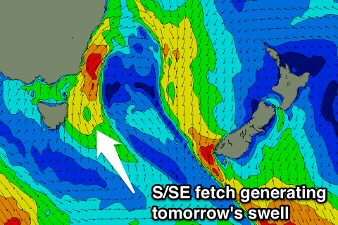 The fetch pushing into our coast at this moment is now looking a little better for swell generation tomorrow.
We'll see swell generating winds tend more S/SE early tomorrow morning and with this the swell hopefully coming in at a good 3ft+ across south facing beaches and northern ends, easing slowly through the day.
Inconsistent amounts of E/NE groundswell should also ease back from 2ft at open beaches.
Winds are due to be from the SW through the morning, more variable into the afternoon, opening up south facing spots from around midday.
Come Friday there isn't due to be much size left at all though, with a rapid drop overnight leaving 1ft+ sets.
Into the weekend, another change moving through Saturday morning doesn't look as good on the charts anymore with the fetch being too short-lived and SW in nature.
South facing beaches may reach 2ft later in the day with onshore winds, fading from 1-2ft Sunday with a NW offshore.
Longer term our S'ly swells for mid-late next week are still on track, but we'll have to take a closer look at the polar frontal progression generating this on Friday.