Mid-week east and south swells, more south swell for the weekend

Eastern Tasmania Surf Forecast by Craig Brokensha (issued Monday 24th April)
Best Days: Wednesday in southern corners, Thursday morning more open beaches, Sunday, Monday
Recap
A small clean NE windswell Saturday morning across magnets, but only to 2ft max on the sets.
Sunday was then tiny and average with a S'ly change. Today was effectively flat and unsurfable.
This week and weekend (Apr 25 - 30)
This coming week we'll see a mix of inconsistent E/NE groundswell for later Tuesday and Wednesday, with some weak S'ly windswell in the mix.
Over the weekend a deepening low above New Zealand, just within our swell window aimed a fetch of E'ly gales towards the Australian East Coast.
 I'm not totally confident on the size off this fetch, as it was slightly tucked in beyond New Zealand's North Cape, but hopefully we'll see some small 2ft to occasionally 3ft waves across open beaches through Wednesday, easing back quickly Friday.
Also in the mix Wednesday will be a building S'ly swell, generated by a strong cold front pushing up past us during the morning. South facing beaches should reach 3-4ft later in the day but with poor S'ly winds. A morning SW wind will favour more open beaches, with the S'ly wind restricting the best waves to southern corners with the inconsistent E/NE swell.
A morning SW'ly is again due Thursday with easing surf in the 3-4ft range across south magnets, tiny Friday.
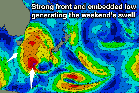
Into the weekend a broader and more elongated cold front will push up past us, generating a good fetch of strong to gale-force S/SW winds through our southern swell window.
With the change Saturday a building S'ly swell is expected into the afternoon, again to the 4ft range but with S'ly winds.
The swell should be longer-lived, with the fetch extending down to the polar shelf along with a stronger and tight embedded low just within our swell window if things go to plan.
A good S/SE groundswell pulse is possible off this low, arriving Sunday afternoon. The morning should be around 3ft at south facing beaches, with the S/SE groundswell pulsing to 4ft before easing Monday.
Conditions are looking much better Sunday as well with W/NW offshores, more W'ly Monday. Longer term more S'ly swell is on the cards for mid-next week, but more on this Wednesday.