Mix of small trade-swell and NE wind swell for the weekend

Eastern Tasmania Surf Forecast by Guy Dixon (issued Wednesday 4th May)
Best Days: Small options to end the week. Wind affected on the weekend. Hopefully Wednesday.
Recap:
Tiny conditions persisting, with no decent surf able swell. Northwesterly winds are keeping conditions tantalisingly clean however.
This week (Thursday 5th - Friday 6th):
As we are all probably well aware now, the long wave trough is not in a very favourable phase for Tasmania, but is instead favouring swell windows to our east and west (Vicco on the pump today).
As a result, any frontal activity will be poorly aligned, with the storm tracks generally moving in a southeastward motion - the complete opposite of the north thru northeastward motion we look for.
Our eastern swell window will otherwise have to take up the slack, with a small, slow increase in east/northeasterly trade-swell on the cards
The strongest and most elongated trade fetch has been established from Tuesday but will start to weaken in the coming days. This weakening trend will be countered by the main fetches tending more east/northeasterly and drifting closer to the coast, setting up a slow and steady captured motion.
We are expecting a gradual increase in easterly swell across the open beaches as a result, remaining small on Thursday, but building to the 1-2ft range by Friday.
Conditions will remain clean for the remainder of the week as winds swing from west/northwest to north/northwest at times.
This weekend (Saturday 7th - Sunday 8th) and Next week (Monday 9th onward):
We should see this easterly energy continue to slowly build on Saturday with sets in the 2ft range late in the day, before peaking on Sunday at a similar size, with the occasional bigger set in the mix.
A north/northeasterly fetch looks to develop off the South Coast of NSW late on Saturday night, increasing throughout Sunday and spreading southward across Bass Strait. The southern extension of this fetch looks to push offshore into Monday morning, but more distant and well aligned north/northeasterly fetches off the NSW coastline should maintain good energy.
We can expect short range energy to build throughout Sunday to around 3ft+ across northeast facing beaches, before peaking on Monday morning in the 4-5ft+ range. Reinforcing mid-range energy from the more distant fetches should maintain options in the 3-5ft range during the afternoon, fading from around 3-4ft range on Tuesday.
Due to this local northerly airflow, options along the open beaches are likely to be quite wind affected, making it tricky to take advantage of the size.
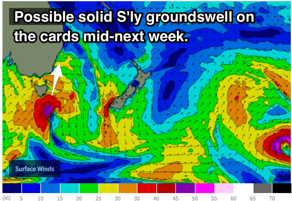 This increasing northerly flow is as a result of a tightening pressure gradient ahead of an approaching front/low, the first decent system in a while. South/southwesterly trailing fetches look to move into out swell window on Tuesday, with good intensity (up 45-50kts).
South facing beaches can expect sets in the 3-4ft range peaking on Wednesday morning, with winds becoming much more favourable by this stage, prevailing from the northwest once again.
Otherwise, the first half of next week should see a slow easing trend across open beaches as this modest trade-swell winds down from the peak on Sunday.