Pulses of S'ly and NE swell, offshore winds each day

Eastern Tasmania Surf Forecast by Guy Dixon (issued Monday 4th April)
Best Days: Saturday.
Recap:
Sunday saw a peak in southerly swell, with exposed south facing beaches picking up sets in the 2ft range. Otherwise, the surf remained generally flat. Saturday was dominated by offshore breezes, persisting throughout Sunday morning before a seabreeze came in just before lunch.
It was a similar story today with a distinct lack of swell and onshore breeze coming in during the middle of the day.
This week (Tuesday 5th - Friday 8th):
As per the previous forecast notes, there isn’t a whole lot of action on the horizon for this part of the world in the next few days.
An inland trough looks to deepen during Tuesday, interacting with a strong ridge over the Tasman. The pressure gradient looks to tighten as a result, steering an increasing local north/northeasterly fetch down the NSW coast.
The southern extension of this trough lacks intensity and does not push well into the east coast of Tasmania, so swell generation is likely to be modest. Open beaches look to build to the 1-2ft range by Tuesday afternoon off the more local fetches, with a touch more size on Wednesday afternoon from further afield, but really only around the 2ft range.
Conditions should remain clean under a north/northwesterly breeze on Tuesday, easing and tending more west/northwesterly on Wednesday.
Southerly energy is then due to build across south facing beaches on Thursday generated by southerly trailing fetches off the back of a deep front and low. Exposed south facing locations should peak in the 2ft range by the afternoon, fading from a similar size on Friday morning, maintained only by south/southeasterly fetches as this system moves east.
Again, northwesterly breezes look to dominate keeping conditions generally clean and workable.
This weekend (Saturday 9th - Sunday 10th):
Saturday holds the next best chance of significant swell, with a couple of pulses of long range southerly energy due to fill in.
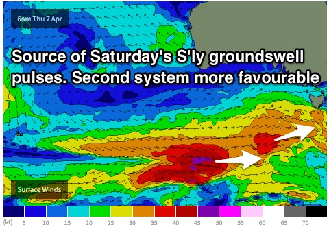 The first pulse is due to originate southwest of WA, moving in a captured motion towards the west coast of Tasmania. The second system looks to move over the active sea-state whipped up by the prior system, moving in a captured motion with better alignment, aimed more to the south.
The zonal motion of these fetches will severely limit swell size, however due to the long periods exposed south facing beaches have the potential to pick up refracted energy with inconsistent sets in the 2ft+ range by the afternoon.
Sunday looks to see a frontal progression move more locally, although the fetches look quite westerly in nature once again. Nevertheless, as light fades south facing beaches have the potential to see the odd 2-3ft set, but more so in the 2ft range.
Northwesterly breezes look to become quite gusty throughout Saturday, tending more west/northwesterly on Sunday while easing.
Next week (Monday 11th onward):
Further ahead, southerly pulses mid-week look much better, with broad southwesterly fetches showing better alignment to the east coast. More detail on Wednesday.