S'ly swell for the weekend, with some better E/SE and E/NE swell for Thursday

Eastern Tasmania Surf Forecast by Craig Brokensha (issued Friday 18th March)
Best Days: Saturday morning, Sunday morning, Wednesday morning, Thursday
Recap
Fun clean and peaky 2-3ft waves yesterday morning with an easing E'ly swell, while today a mix of E'ly and new NE windswell were providing solid 3-4ft peaks across north-east facing beaches, cleaning up through the day as a change moved through.
This weekend and next week (Mar 19 - 25)
The NE windswell will be all gone by tomorrow, replaced by a short-range S'ly swell generated by today's strong S/SW change.
A short-lived fetch of S/SW gales will be generated in our swell window, followed by a secondary burst tomorrow morning, producing a mix of S'ly swells.
South facing beaches should see sets in the 3ft+ range most of the day, but open beaches will be much smaller and only around 1-2ft.
The swells should fade into Sunday out of the S/SE from 2-3ft at south swell magnets, and 1-2ft at open beaches.
Offshore SW winds will swing S'ly tomorrow, with better W'ly breezes Sunday morning ahead of E'ly sea breezes.
Into next week a small mix of leftover SE swell and long-range E/NE trade-swell are expected, but only to 1-2ft max across open beaches Monday and Tuesday morning.
Of greater importance is the development of a broad low pressure system off New Zealand, generating a broad fetch of strong SE winds through our swell window, and stronger E/NE gales through our eastern swell window.
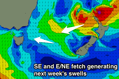 The SE fetch should produce a fun pulse of E/SE swell through Wednesday afternoon and Thursday in the 2ft+ range, while the E/NE fetch should produce a better E/NE groundswell for Thursday, peaking into the afternoon. Open beaches are looking at good 3ft+ sets, but we'll review this Monday.
Winds are looking good from Wednesday into the end of the week, with less than ideal conditions Monday and Tuesday. Have a great weekend!