Thursday looking good - light winds, fun E/NE swell

South East Queensland and Northern New South Wales Surf Forecast by Guy Dixon (issued Monday 4th January)
Best Days: Thursday.
Recap:
Sunday’s peak in northeasterly groundswell held true, with open beaches building to the 3-4ft mark. Unfortunately, an easterly breeze dominated the coast for much of the day, taking the edge of the quality.
Today, the surf has eased back a touch, however open beaches are continuing to see the odd 3ft set.
This week (Tuesday 5th - Friday 8th):
The surf will ease back significantly into Tuesday, with open beaches picking up options in the 2-3ft range, maintained only by a weak easterly airflow over the Tasman which has shown better alignment to the NSW coast throughout today.
We are looking at northeasterly breezes persisting, easing into the afternoon.
The impacts of this ridge will fade into Wednesday, with easterly swell fading to the 2ft range, however hints of a southerly groundswell should also be in the water following a front which crossed the deep Southern Ocean earlier in the week.
 The south/southwesterly swell direction however will limit options to only the most exposed southerly swell magnets, with inconsistent 1-2ft sets a chance. Keep your expectations heavily grounded.
The morning session can expect light/variable-offshore breezes early, increasing from the south/southeast later.
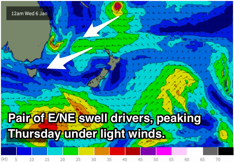
The most significant swell driver will then become a long-range east/northeasterly fetch located north of NZ as a strong ride interacts with TC Ula to the north, and a trough/developing low of the coast of NSW. Open beaches should expect options to build to the the 3ft range by Thursday afternoon.
TC Ula itself should also add some very inconsistent energy into the mix, particularly for the open beaches with occasional sets in the 3ft range.
Conditions are looking to remain easily workable and fairly clean throughout Thursday, with only a light southerly airflow along the coast, easing and tending east/southeasterly late. If it’s bumpy, a clean wave shouldn’t be far away.
A second groundswell looks to move up the coast on Friday, however similarly to Wednesday’s pulse, swell direction will be an issue. We are only expecting 1-2ft sets, at best, at the most exposed magnets, nothing amazing.
Open beaches would be my pick with long range TC Ula energy still filling in, despite winds potentially becoming gusty from the north/northeast preaching a weak southerly change.
This weekend (Saturday 9th - Sunday 10th):
Southerly swells generated by frontal activity is likely to be the most dominant swell for the best part of the weekend, although not much in it. The story continues, too much west and not enough power. Exposed magnets may only see 1-2ft options on Saturday, smaller on Sunday.
However, an increasing north/northeasterly fetch on Sunday afternoon should provide a few small windswell peaks to around 2ft by the late afternoon.
There is still some model uncertainty regarding the finer details of winds on the weekend, however we should see a fair chance of light/variable, possibly offshore breezes each morning, particularly Sunday.
Next week (Monday 11th onward):
Things then look to settle down for eastern Australia, with a broad and dominant ridge building over the region. We hope for more dynamic systems on the models for Wednesday forecast.