Easing S/SE swell, new S'ly swells next week

Eastern Tasmania Forecast by Craig Brokensha (issued Wednesday 8th July)
Best Days: Thursday, Friday morning, Tuesday
Recap
Poor winds with moderate amounts of S'ly and S/SE swell yesterday, while today we saw cleaner conditions with 2-3ft sets at open beaches and bigger waves at south swell magnets.
This week and weekend (Jul 9 – 12)
 Today's S/SE swell is due to ease into tomorrow from 3ft+ across south facing beaches, down further from 2ft Friday morning.
Winds will be great and offshore from the NNW-N/NW into the end of the week, and even Saturday but the swell will be tiny.
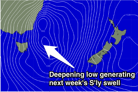
Later Sunday we may see some weak S'ly windswell building across the coast due to a deepening low pressure system across the south-east of the country, but Monday and Tuesday will reveal more size.
Into Monday we'll see a fetch of strong S/SW winds developing off our coast, kicking up some new S'ly windswell to 3ft or so across south facing beaches, but with average SW winds.
A reinforcing fetch of S/SE tending S'ly winds will be projected up into us Monday evening, producing a spike in S'ly swell for Tuesday with possible W'ly winds.
The models are moving around regarding all this though, so we'll have to have a closer look at the forecast on Friday. At this stage Tuesday looks to be the best day to surf.