South swell on the menu, best from Friday

Eastern Tasmania Forecast by Craig Brokensha (issued Monday 29th June)
Best Days: Wednesday morning south swell magnets, Friday and Saturday morning south swell magnets, Monday and Tuesday
Recap
Tiny weekend of waves for the most part besides a late kick in acute S'ly groundswell yesterday, but it was gone by this morning.
This weekend and next week (Jun 30 – Jul 5)
Tomorrow is expected to remain tiny to flat, with a possible small and fleeting pulse of S'ly groundswell Wednesday morning. This won't offer too much size, with the intense polar low generating it under us this evening and early tomorrow, tracking unfavourably to the east-southeast.
South facing beaches may see a small 2ft+ wave early, before fading into Wednesday.
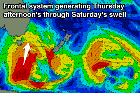
Of greater importance is the storm track moving into a more favourable position later in the week, as a node of the Long Wave Trough strengthens across the southern Tasman Sea.
This should direct the polar frontal activity up through the southern Tasman Sea and more through our swell window, with an initial system pushing through Thursday.
This should produce a building S'ly swell to 3-4ft across south facing beaches, but with poor SW winds.
A trailing fetch of S/SW gales stretched to the polar shelf should produce a better S'ly groundswell pulse for Friday afternoon, keeping 3ft+ sets hitting south facing beaches under better W/NW winds.
Saturday morning should still offer 2-3ft sets, before fading through the day.
The next pulse of S'ly groundswell may be seen late Sunday, but more so Monday/Tuesday, from a slightly weaker but better aligned polar frontal progression pushing under us over the weekend.
We're probably looking at swell around the 3-4ft range, but we'll have a closer look at this on Wednesday.