Great weekend of surf with mix of E/SE and S'ly swells

Eastern Tasmania Forecast by Craig Brokensha (issued Friday 19th June)
Best Days: Saturday, Sunday, Monday morning
Recap
Stormy and junky SE swell yesterday with plenty of size, while today, the swell backed off more to the 3-4ft range but cleaned up nicely, with pumping waves on offer through the day.
This weekend and next week (Jun 20 - 26)
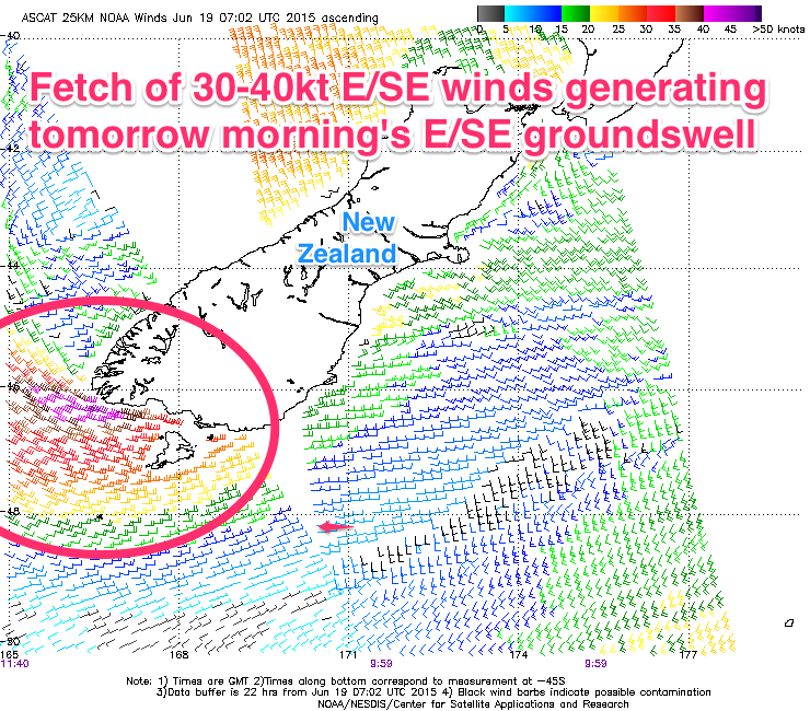 Today's SE groundswell should of ease off a touch into this afternoon, but a new E/SE groundswell pulse is due tomorrow morning, from a fetch of gale to severe-gale E/SE winds off the tip of New Zealand's South Island, confirmed by satellite.
This should come in at a strong 3-4ft across open beaches tomorrow morning, easing into the afternoon and further down from 2ft+ Sunday morning.
Also in the mix will be a building S'ly groundswell, generated by a vigorous polar low tracking along the polar shelf and then up towards New Zealand the last couple of days.
This should build to 4-5ft across south swell magnets through the day before then easing back from 3-4ft Sunday morning.
A secondary S'ly groundswell pulse is due through the afternoon though, keeping 3ft+ sets hitting south facing beaches before fading quickly Monday from 2-3ft.
Winds tomorrow should be offshore from the W, tending W/SW through the day and then Sunday great with W/NW tending light N/NE winds. As the swell eases Monday, strengthening N/NW winds will keep south swell magnets clean.
There's nothing significant on the cards for the rest of the week besides possible small levels of building NE windswell mid-week. Therefore make the most of the coming weekend of swell! Have a good one!