Lots of swell, dicey winds

Eastern Tasmania Forecast by Craig Brokensha (issued Monday 15th June)
Best Days: Tuesday morning south swell magnets, Wednesday morning north-east swell magnets, Friday, Saturday, Sunday morning
Recap
Tiny S'ly swell all weekend with generally favourable winds, while today a new S/SE groundswell started to build, coming in at 2-3ft this morning. A further increase to 3-5ft at swell magnets was expected this afternoon but S'ly winds would of limited options.
 This week and weekend (Jun 16 - 21)
Today's kick in S/SE groundswell is due to ease off into tomorrow, with inconsistent but good 3ft+ sets due across swell magnets, backing off more to 2ft through the afternoon.
Winds are looking average though with early N'ly tending NE breezes due, favouring northern corners.
These NE winds will however be linked to a deepening surface trough to our north-east, with a burst of fresh to strong NE winds due to be aimed towards us through tomorrow before pushing off to the east Wednesday.
A small and short-lived NE swell is due off this, building to 2ft+ later tomorrow and easing Wednesday morning from 2-3ft across north-east swell magnets, back to 1-2ft through the day.
Winds will favour locations picking up the most size as a strong S'ly change pushes through, bringing a late increase in building S'ly swell, likely to 3-4ft on dark across south swell magnets.
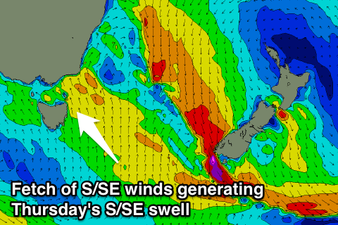
This S'ly change will be related to a broad fetch of strong S/SE winds pushing up through the southern Tasman Sea, and this should see the swell swing more S/SE into Thursday and ease from 3-4ft+ across south facing beaches.
Winds will unfortunately remain poor and fresh to strong but easing from the S/SE leaving no real options for a decent surf.
Friday will be the best day to surf as the swell swings more SE and eases from the 3ft range across open beaches with offshore W/NW winds.
One final pulse of SE groundswell is due into Saturday though, generated by a tight fetch of SE gales off the tip of New Zealand's South Island Thursday, offering infrequent 2ft to possibly 3ft sets across the coast before fading Sunday.
Also in the mix though should be a strong pulse of S'ly groundswell, generated by a vigorous polar low pushing through our swell window this week.
This low will generate a fetch of gale to severe-gale W/SW winds through our southern swell window before being projected up towards New Zealand while easing Friday.
A strong S'ly groundswell should be seen across south facing beaches, peaking through the morning to 3-5ft. Winds look good and offshore from the W/NW, but we'll confirm this again on Wednesday.