Great tomorrow and Friday mornings

Eastern Tasmania Forecast by Craig Brokensha (issued Wednesday 14th January)
Best Days: Thursday morning, Friday morning
Recap
Yesterday was poor with a slow increase in NE swell with average winds. Today though a strong NE swell started to fill in from a deepening low off our coast along with a broad fetch of NE winds off the Southern NSW coast.
This morning saw 3-4ft waves, but a much larger pulse has surfaced this afternoon to 4-6ft, with the winds off the Southern NSW coast coming in a touch stronger than expected.
Winds from the southern quadrant have left southern corners with pumping waves.
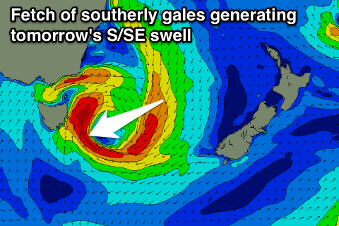 This week (Jan 15 - 16)
This afternoon's strong kick in NE swell was generated by a broad fetch of strong to near gale-force NE winds off the Southern NSW coast this morning, and this fetch has since been pushed east and away from our swell window.
With this a steep drop in size is expected overnight, with the swell dropping from the 3ft range across north-east facing beaches. A new S/SE swell will be in the water though as the western flank of the low sitting off our coast directs a fetch of gale to severe-gale S/SE winds through our southern swell window from this afternoon, into early tomorrow.
South facing beaches are expected to offer solid 4-5ft waves during the morning before easing through the day and further from 2-3ft Friday morning down to 1-2ft during the day.
Winds will be favourable and offshore from the W/SW tomorrow morning before swinging S/SE into the afternoon, with Friday seeing NW-W/NW winds all day.
This weekend onwards (Jan 17 onwards)
There isn't expected to be any swell left into Saturday with tiny 0.5-1ft leftovers across the coast.
The South Arm is expected to see some moderate sized W/SW groundswell over the weekend, but the frontal progression generating this swell looks to be too west in nature to generate any size for us until its positioned to our south-east on Sunday.
A broad fetch of SW gales should generate a small refracted S'ly groundswell for south swell magnets late in the day but more so Monday morning to 2-3ft. Winds look poor though and onshore from the S/SW, swinging NE later in the day as the swell eases.
Into Tuesday some strong NE windswell is again due to develop across the coast as a very broad and strong fetch of NE winds extend down from the Southern NSW coast to our region. At this stage we're looking at 4-5ft of NE windswell later in the day, but we'll review this Friday.
One final note, it's worth noting a small and inconsistent S/SE swell due across south swell magnets Monday and possibly Tuesday from the low tracking south-east from our state over the coming days. A polar fetch of strong to gale-force S/SE winds are due to be generated, but only a small 2ft of swell is likely. We'll try and nail this down on Friday as well.