Great Wednesday and Thursday morning

Eastern Tasmania Forecast by Craig Brokensha (issued Monday 12th January)
Best Days: Wednesday in southern corners, Thursday morning, Friday morning
Recap
Saturday was poor across most spots and best in protected southern corners with a moderate to fresh S/SE breeze and small NE swell to 2ft+.
The NE swell kicked a touch into Sunday to 2-3ft under morning NW winds ahead of fresh E'ly sea breezes.
Today the the swell was back to 2ft or so out of the NE with clean conditions during the morning before sea breezes kicked in.
 This week (Jan 13 - 16)
We've got lots of swell on the cards for this week, but also a very complex forecast.
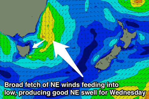
Firstly an inland surface trough will support the formation of a low pressure system as it moves offshore during tomorrow evening, with a broad fetch of NE winds being aimed into us before it does so.
This should kick up building levels of NE windswell later tomorrow, reaching 2ft+ across north-east facing beaches, with smaller levels of background E/NE and NE swells to 1-2ft through the morning. Winds will be average though and fresh from the N/NE tending NE.
A peak in size is due on Wednesday and the low should slip south-east swinging winds fresh offshore from the SW-S/SW as we fall under the influence of the western flank of the low.
Exposed beaches are due to offer 3ft+ sets, with a long-range trade-swell signal also in the water to an infrequent 2ft to occasionally 3ft.
With us under the influence of the western flank of the low we're expected to see a return fetch of S'ly gales aimed through our swell window overnight Wednesday and Thursday morning, producing a fresh S'ly swell Thursday morning to 3-4ft across south facing beaches, easing through the day. There'll also be fun levels of E/NE swell in the water, easing from 2-3ft across north-east facing beaches.
Winds look great and offshore W/SW ahead of E/SE sea breezes. Therefore both Wednesday and Thursday are looking great for a surf, especially with the mix of swells Thursday morning.
Into Friday there isn't expected to be much size leftover with a mix of easing S/SE and E/NE swells from 2ft under strengthening N/NW tending W/NW winds.
This weekend onwards (Jan 17 onwards)
Saturday and Sunday morning aren't expected to offer any major size, but a stalling cold front south and then south-east of the state Sunday and Monday may see some good S'ly and then S/SE groundswell impacting south facing beaches from later Sunday through Tuesday. We'll have another look at this on Wednesday though.