Fun fading E/NE swell tomorrow, better S'ly swell Tuesday/Wednesday

Eastern Tasmania Forecast by Craig Brokensha (issued Wednesday 5th November)
Best Days: Thursday morning, Wednesday morning semi-protected beaches
Recap
Monday S'ly swell backed away considerably into yesterday leaving smaller 1-2ft waves across the coast under early offshores.
Strengthening N/NE winds into the afternoon and off the coast kicked up some punchier NE windswell today to 2-3ft but with onshore winds. More variable winds have developed this afternoon but the swell would have been quite lumpy and sloppy across most beaches.
This week (Nov 6 - 7)
Even though a late S'ly change is due across the region this evening we should still see small levels of E/NE swell across the coast tomorrow as a fetch of strong NE winds remained aimed towards us this evening before pushing too east and out of our swell window tomorrow.
The direction of the swell will swing more easterly as a result of the fetch moving more into our eastern swell window. Open beaches should offer 2ft+ sets with before backing off to 1ft to maybe 2ft Friday.
Winds will be great and offshore from the W/SW tomorrow morning before afternoon sea breezes kick in. Friday should then see W/NW tending N/NW winds.
 This weekend onwards (Nov 8 onwards)
There's nothing too major on the cards for the weekend besides a local increase in N/NE windswell Saturday afternoon ahead of a late W'ly change. Size wise north-east facing beaches should reach 1-2ft, but that's about it before fading overnight leaving tiny surf into Sunday.
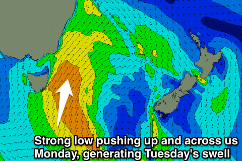
We're looking at some better S'ly groundswell into next Tuesday and Wednesday now with a strong mid-latitude low pushing in from the west due to project north up across the state and past our coast Monday evening.
A broad fetch of S/SW gales will be generated through our swell window, producing a medium sized S'ly swell for Tuesday, peaking through the afternoon before easing Wednesday from the S/SE.
South facing locations should reach 3-5ft during Tuesday afternoon before easing from 3-4ft Wednesday morning.
Winds will unfortunately be poor and fresh to strong from the SW tending S'th Tuesday with weaker S/SW tending SE winds Wednesday.
Thursday will be the cleanest but the swell will be easing from 2-3ft or so. More on this Friday though.