Tiny to flat for the period

Eastern Tasmania Forecast by Craig Brokensha (issued Wednesday 10th September)
Best Days: No good days
Recap
A junky NE windswell built through yesterday with 3ft waves through the morning, increasing further into the afternoon as winds improved slightly, swinging N/NW late.
Today was the day to surf though as winds swung offshore and the swell dropped away from 2-3ft across exposed spots.
This week onwards (Sep 11 onwards)
We'll continue to see the NE windswell drop across the coast into tomorrow as the synoptic setup generating the swell continues to drift east away from us towards New Zealand.
There may be the odd 1ft to possibly 2ft set early but it'll quickly fade under fresh to strong W'ly winds.
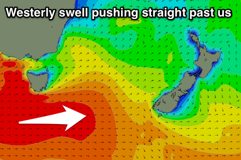 Unfortunately there's nothing major on the cards at all for the rest of the period with all the action being focussed into SA, Victoria and our West Coast.
We may see a small spike in S'ly swell Monday as a cold front glances the coast but the potential off this system has been downgraded in recent runs, with only a small 2ft wave likely at south swell magnets.
Longer term we may see a better cold outbreak later next week across the region, but we'll review this Friday.