Small weekend, plenty of S'ly swell next week

Eastern Tasmania Forecast by Craig Brokensha (issued Friday 8th July)
Best Days: Saturday morning, Monday in protected spots, Tuesday, Wednesday, Thursday morning
Recap
Small lines of S'ly swell pushed up the coast yesterday but today, a much larger and stronger S'ly groundswell due across the coast wasn't reported to be present at dawn with surf in the 2ft range.
We should of seen the swell kick in during the morning though, as Clifton saw solid 3-5ft waves this morning from the same swell. Conditions are clean and will remain so this afternoon as the swell peaks in size.
This weekend and next week (Aug 9 - 15)
Today's strong pulse of S'ly groundswell should peak this evening but drop back considerably overnight due to the fast tracking nature of the front generating the swell.
South swell magnets should still pick up 2ft+ sets before fading through the day under strengthening NW winds.
The S'ly swell pulses for next week are looking much better with a polar front moving in from the west this weekend expected to now fire up significantly to the south of the state Saturday evening.
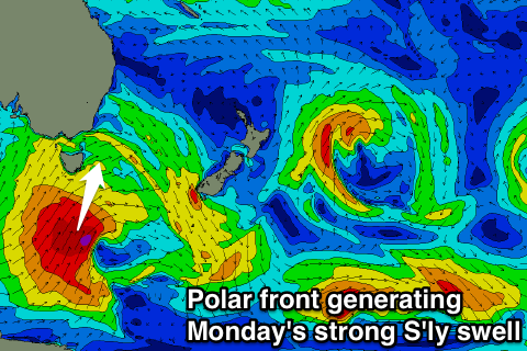 This front is forecast to project a fetch of severe-gale S/SW winds from the polar shelf, up past our coast and into the Tasman Sea. This will produce a large S'ly groundswell for Monday, peaking during the day to 4-6ft at exposed south facing breaks, with 3ft+ surf at open beaches.
Winds will unfortunately be fresh from the SW to S/SW limiting surfing options to more protected and smaller breaks. Tuesday is looking cleaner as the swell eases from 3-5ft or so at exposed south facing breaks under straighter W/SW tending SW winds.
Another weaker front pushing up past us on a less favourable north-east track Tuesday evening should produce a secondary smaller S'ly groundswell pulse for Wednesday afternoon to 3-4ft across south facing breaks. Winds look as if they'll be straighter W'ly before going onshore into the afternoon with W'ly tending S'ly winds into Thursday as the swell eases.
Longer term there's nothing significant on the cards unfortunately so make the most of today's S'ly groundswell pulse and the waves on offer early next week. Have a great weekend!
Comments
Might be time for an update re' upcoming ne swell event ;)
Bit busy as Ben is away at the moment sorry SD. Swell is on the cards from Sunday onwards from the NE, but it's still a while away. Might get a chance to update Thursday/Friday.
A very interesting week ahead, Craig...... This system should rock the whole east coast from tassie to sunny coast in some way...... Those up in Qld may have to wait till next wed/thurs.... Might get some small ne "back of the low stuff" before then..... But next week looks the goods..... Meanwhile, Tassie, NSW set to rocknroll.....
Map for se swell qld next week.......