Tuesday the best ahead of a tiny period

Eastern Tasmania Forecast (issued Monday 23rd June)
Best Days: Tuesday morning
Recap
Saturday started off slow as expected before the arrival of a new long-period S/SE groundswell through the day. This pulsed into the afternoon and held well into Sunday morning with 3ft to occasionally 4ft sets across the coast under offshore winds.
Another pulse should have been seen today, but a larger N/NE windswell overrode the SE groundswell signal under N/NW winds.
This week (Jun 23 - 27)
One final pulse of SE groundswell that should have been present across the coast under the N/NE windswell today should still be visible in the water tomorrow morning.
The N/NE windswell will back off considerably overnight as winds swing offshore from the W/NW but both swells should still provide peaky 2ft+ waves across open beaches. It'll be worth making the most of tomorrow morning because there's nothing major due through the rest of the period until next week.
This will be the result of the westerly storm track firing up and becoming quite zonal, directing front after front across Southern Australia.
The strongest is due on Thursday and even though the models have an increase in size, this is an error we need to fix. The dead giveaway is the W'ly swell direction, which is impossible across our region.
This weekend onwards (Jun 28 onwards)
The weekend will most likely remain flat as the frontal activity remains just west of us, but into early next week we should see the storm track move into a much more favourable position.
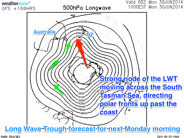 This will be a result of an amplification of the Long Wave Trough moving across the entrance of the Southern Tasman Sea, directing polar frontal activity up past our coast.
The models still diverge on the exact timing of this development but we should see some better S'ly swell activity into early next week. Check back here on Wednesday for more on this though.