Large swell for the weekend, good swells next week

Bali and Mentawais forecast by Craig Brokensha (issued Thursday 13th July)
Best Days: Every day from late Friday
This week and next (Jul 14 - 21)
Bali: A slight bumpy in inconsistent S/SW swell across the region today but still small and slow.
Similar surf will continue into tomorrow morning, but later in the day our first pulse of new long-period S/SW groundswell should be seen, ahead of the larger increase Saturday.
 Friday afternoon's swell will be the least consistent of the two, with exposed breaks expected to reach 4-6ft by dark (our models are incorrectly combining background swell energy with the new long-period S/SW groundswell).
The secondary swell has been generated for a better aligned and broad fetch of severe-gale SW winds projecting towards WA the last couple of days.
We should see the swell building into Saturday afternoon, reaching 8-10ft across exposed breaks, easing slowly Sunday from the 8ft range Sunday, smaller Monday.
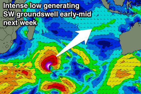
A temporary low point is expected Tuesday morning ahead of a new long-period SW groundswell into the afternoon.
This swell is currently being generated by a deep mid-latitude low south-east of Madagascar, with a fetch of severe-gale to storm-force W/SW winds being projected east through our south-western swell window.
 The low will continue east over towards WA while slowly weakening, with the long-period energy due to build Tuesday afternoon to 5-6ft across exposed breaks by dark, easing from a similar size Wednesday morning.
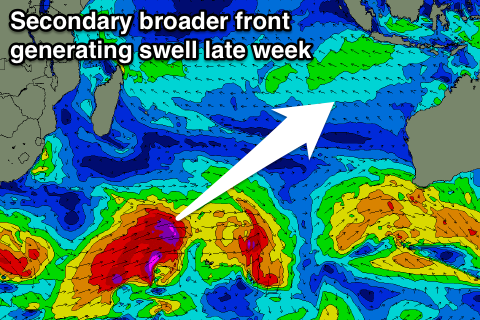
Later in the week a secondary slightly larger SW groundswell is expected, produced by a broader and more sustained fetch of severe-gales moving through our swell window from under South Africa, through the Indian Ocean from Friday into Sunday.
We may see a late increase in size Thursday ahead of the groundswell proper Friday, coming in around 8ft at exposed breaks. We'll review this swell again on Thursday though.
Looking at the expected winds over the coming period and fresh E/SE trades are due over the coming days (light and variable each morning) before weakening off from the middle of next week.
16 day Bali Forecast Graph
16 day East Java Forecast Graph
16 day Sumbawa Forecast Graph
Ments: A slight bump in swell has been seen today, but our attention turns to the weekend, with the large new S'ly groundswell still on track to deliver 6-8ft+ waves across exposed south facing breaks Saturday with light variable winds.
This swell should ease slowly Sunday, with a more noticeable drop Monday ahead of our new SW groundswell Tuesday.
This swell is being generated closer to us than Bali and we should see a touch more size with 5-6ft+ sets due across magnets, easing back into Wednesday.
The secondary groundswell for later in the week will come in a little more from the S/SW and should build Thursday afternoon to the 6-8ft range, but we'll review this Tuesday.
Winds should remain variable through the period besides a slight freshening from the E/SE Monday.
16 day Mentawai forecast graph
16 day Nias forecast graph
16 day South Sumatra forecast graph
Comments
Sat Sun..Padang comp ?
Awesome
The new swell showing on the Ulu cam.
Sorry Udo, missed this comment. Nah not big enough :p
Here's the latest forecast, great period!