Large easing surf, new SW swell from next weekend

Bali and Mentawais forecast by Craig Brokensha (issued Thursday 11th May)
Best Days: Bali Thursday through Monday morning, Tuesday through Thursday then later next weekend onwards (Ments Thursday through Sunday, then late Monday/Tuesday and next weekend onwards)
This week and next (May 12 - 19)
Bali: A large and powerful SW groundswell is currently filling in across the region with good clean conditions (pictured below). We should see the swell peaking later this afternoon/evening to 10ft+ across exposed breaks on the sets ahead of a slow drop back from 8-10ft tomorrow morning.
The swell will continue to ease through the coming days, bottoming out Monday afternoon and Tuesday. Moderate to fresh E/SE trades are expected over the coming days, lighter and more variable each morning favouring more exposed breaks.
Our small to moderate sized mid-period S/SW swell for early-mid next week is still on track, with a couple of back to back but relatively weak polar fronts projecting up towards us yesterday, today and tomorrow.
A small bump in background SW groundswell is due Tuesday to an inconsistent 3-5ft into the afternoon, while the more consistent but weaker S/SW swell is due Wednesday to 4-5ft or so.
The swell should then slowly ease back through the rest of the week, smaller into next Saturday. E/SE trades are expected to swing slightly more SE late next week (still light and variable each morning).
Longer term we've got some better long-period SW groundswell due from Sunday and more so early next week across the islands.
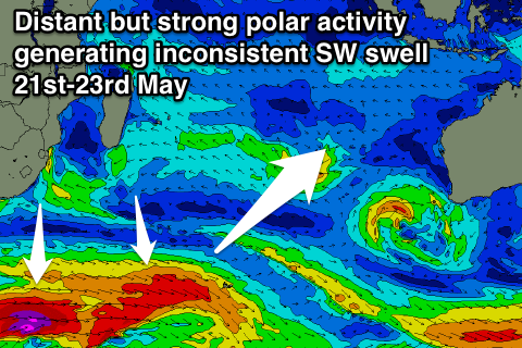 This swell will be generated in two separate areas. Firstly some strong but distant polar fronts will generate a flurry of severe-gale pre-frontal and post-frontal W/NW and W/SW fetches, with stronger storm-force winds south of South Africa.
This is in our far south-western swell window, but one of the fronts is forecast to project north-east and over the top of the long-range energy travelling towards us. An additional fetch of strong to gale-force SW winds projected much closer towards us should generate some more consistent mid-period energy that should arrive around a similar time.
A third front generating stronger gales should then produce a secondary reinforcing SW groundswell.
The first pulse of long-period and very inconsistent SW swell is due to build later Saturday to 3-4ft+ at magnets by dark, increasing further to 4-6ft through Sunday. The waits between sets will be excruciating though and upwards of 10-15 minutes.
The best long-period swell and mix of mid-period energy are due to fill in Monday, building to 6-8ft at exposed breaks, with the secondary reinforcing swell for Tuesday to a similar size.
A steady drop in swell is then due through Wednesday through the rest of the week. This is a long way away though, so check back Tuesday for the latest on this.
16 day Bali Forecast Graph
16 day East Java Forecast Graph
16 day Sumbawa Forecast Graph
Ments: Large powerful surf today with the S/SW groundswell filling in. We should see this swell easing back from tomorrow with 8ft sets at south magnets, further down through the weekend, bottoming out Monday morning.
The small mid-period S/SW swell is expected to build later Monday to 3-5ft, peaking Tuesday more to 4-5ft before easing late.
From here we're looking at a slow period with the swell backing right off before the distant S/SW groundswell fills in.
We should see the first and least consistent swell building Saturday and reaching 5-6ft into the late afternoon, with the secondary mix of swells continuing to build Sunday to 6-8ft, holding Monday. From here the swell is due to ease off.
Winds over the coming period look favourable with variable breezes, taking a slightly S/SE tendency next week. We'll have another look at this Tuesday though.
16 day Mentawai forecast graph
16 day Nias forecast graph
16 day South Sumatra forecast graph