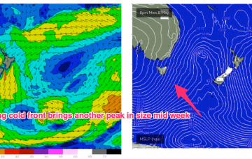
The front interacts with the trough to form a surface low off the North Coast but consistent with Fridays notes the surface low is expected to rapidly move away towards New Zealand later Wed into Thurs, with a short spike in swell for NETas. More small S swell pulses are expected in the medium term.
Primary tabs
/reports/forecaster-notes/eastern-tasmania/2023/05/15/s-swell-spike-tue-more-small-s-swell-the-medium
freeride76
Monday, 15 May 2023
/reports/forecaster-notes/eastern-tasmania/2023/05/12/few-days-tiny-surf-get-through-small-s-swell
freeride76
Friday, 12 May 2023
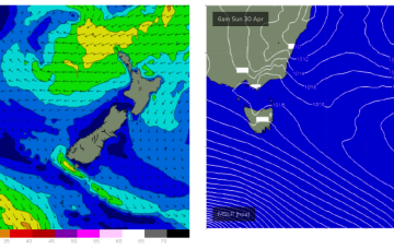
No swell sources for the weekend so we’re looking at tiny surf across the weekend with just a slight increase in minor S swell Sunday, no more than 1ft though.

/reports/forecaster-notes/eastern-tasmania/2023/05/10/tiny-surf-ahead-s-swell-spike-next-week
freeride76
Wednesday, 10 May 2023
High pressure moves into the Tasman as we end the week with a dominant role into next week , before a front and possible low brings another strong S’ly surge with an accompanying S swell next week.
/reports/forecaster-notes/eastern-tasmania/2023/05/08/solid-s-swell-pulse-mid-week-period-tiny-surf
freeride76
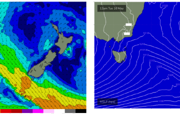
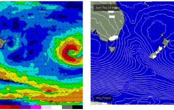
Monday, 8 May 2023
A 996 hPa low just off the coast and a 1034 hPa high in the Bight is creating a very tight pressure gradient with subsequent severe gales and an L-XL S swell event for NSW, with smaller but still significant S swell expected for Tasmania.
/reports/forecaster-notes/eastern-tasmania/2023/05/05/some-strong-pulses-s-swell-next-week-cold
freeride76
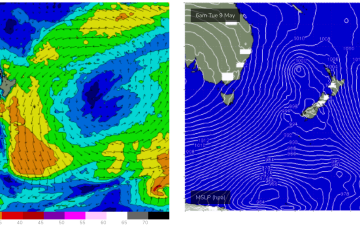
Friday, 5 May 2023
Sunday looks more dynamic as a low forms to the NE of the state and a S’ly fetch extending to the south of the Island generate new S swell.
/reports/forecaster-notes/eastern-tasmania/2023/05/03/large-swells-expected-next-week-deep-low-sits
freeride76
Wednesday, 3 May 2023
A much stronger cold outbreak looks poised to spawn a major Tasman Low Sun/Mon with the seasons first serious S-SE swell expected.

/reports/forecaster-notes/eastern-tasmania/2023/05/01/fun-pulses-e-swell-week-cold-outbreak-ahead
freeride76
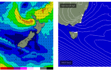
Monday, 1 May 2023
We should see some small S swell later in the week as a minor front/low pushes into the Tasman before a more substantial S swell event develops late in the weekend/early next week on the back of a cold outbreak and potential deep low in the Tasman.

/reports/forecaster-notes/eastern-tasmania/2023/04/28/fun-ne-swell-early-next-week
Craig
Friday, 28 April 2023
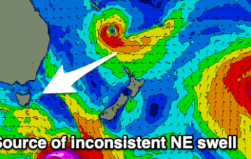
The weekend will become small and slow, with some new, inconsistent NE swell due next week.
/reports/forecaster-notes/eastern-tasmania/2023/04/26/couple-fun-days-ne-swell-better-quality-ene
freeride76
Wednesday, 26 April 2023
A broad trough of low pressure is expected to bud a surface low near New Caledonia over the short term, generating more quality E-E/NE swell as the low drifts through the South Pacific slot and into the Tasman.
/reports/forecaster-notes/eastern-tasmania/2023/04/24/eyes-the-ne-windswell-then-groundswell
freeride76
Monday, 24 April 2023
The major swell generator will a broad fetch of SE-E/SE winds in the Coral Sea/Northern Tasman which will be enhanced later in the week as a broad tropical low tracks southwards from New Caledonia and into the wide open Eastern swell window, bringing quality E/NE swell to NE Tas later in the weekend and early next week.