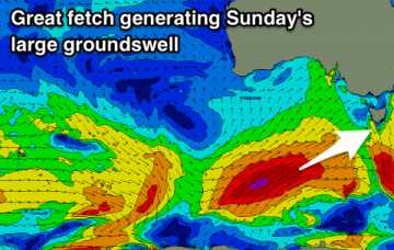
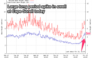
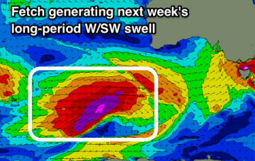
Easing SW groundswell tomorrow with back to back pulses of moderate sized swells from Sunday, with windows of good winds.
Primary tabs
/reports/forecaster-notes/southern-tasmania/2018/09/21/constant-swell-sources-windows-good-winds
Craig
Friday, 21 September 2018
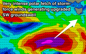
/reports/forecaster-notes/southern-tasmania/2018/09/19/upgrade-sw-groundswell-due-late-week
Craig
Wednesday, 19 September 2018
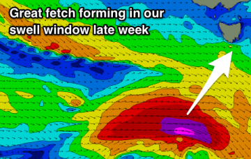
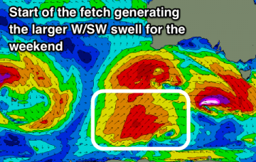
Easing surf tomorrow ahead of a strong pulse of new SW groundswell through Friday, easing into the weekend followed by plenty more activity.
/reports/forecaster-notes/southern-tasmania/2018/09/17/good-active-period-ahead
Craig
Monday, 17 September 2018
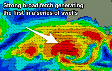
Plenty of swell on the cards with the LWT coming to play from the weekend.
/reports/forecaster-notes/southern-tasmania/2018/09/14/good-active-period-plenty-swell-come
Craig
Friday, 14 September 2018
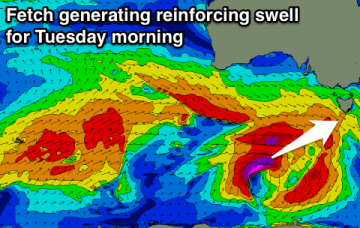
Various pulses of swell mostly from the west with generally decent winds.
/reports/forecaster-notes/southern-tasmania/2018/09/12/good-swell-energy-late-week-persisting-all
Craig
Wednesday, 12 September 2018
Not much on the cards until late in the week, with plenty of swell on the weekend, biggest Sunday.
/reports/forecaster-notes/southern-tasmania/2018/09/10/easing-surf-ahead-increase-activity-later
Craig
Monday, 10 September 2018
Good fun waves tomorrow, tiny until later week and solid through the weekend.
/reports/forecaster-notes/southern-tasmania/2018/09/07/fun-clean-swells-early-next-week
Craig
Friday, 7 September 2018
Tiny to flat weekend with some new swell kicking later Sunday, with better energy through early next week and clean conditions.
/reports/forecaster-notes/southern-tasmania/2018/09/05/no-significant-swell-until-next-week
Craig
Wednesday, 5 September 2018
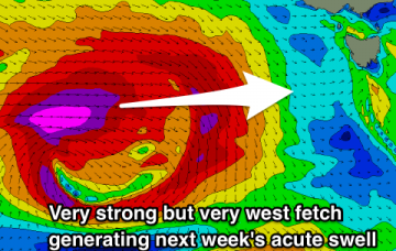
Tiny swells ideal for beginners over the coming few days ahead of a better though acute W'ly groundswell next week.
/reports/forecaster-notes/southern-tasmania/2018/09/03/easing-surf-fun-new-swell-arriving-through
Craig
Monday, 3 September 2018
Clean conditions and easing swells over the coming days with no significant new swell action until the weekend arrives.
/reports/forecaster-notes/southern-tasmania/2018/08/31/tons-swell-becoming-quiet
Craig
Friday, 31 August 2018
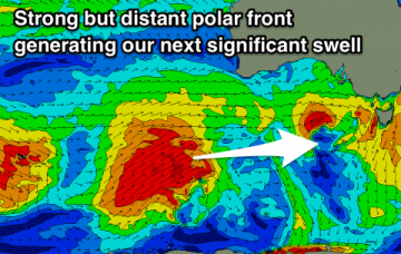
Onshore winds all weekend but with a large new groundswell for Sunday, cleaner and easing into early next week.