Easing surf, fun new swell arriving through the weekend
Southern Tasmania Surf Forecast by Craig Brokensha (issued Monday 3rd September)
Best Days: Tuesday, Wednesday morning, later Sunday and Monday
Recap
Poor onshore and small waves on Saturday morning, building through the afternoon ahead of a much larger and more powerful swell filling in Sunday offering good waves in protected spots through the afternoon.
This morning winds swung back offshore across Clifton with a solid easing groundswell from 3-4ft.
Today’s Forecaster Notes are brought to you by Rip Curl
This week and weekend (Sep 4 - 9)
Today's S/SW groundswell should of continued easing through this afternoon, and will be all but gone tomorrow, replaced by a reinforcing W/SW swell from a fetch of pre-frontal W/NW gales moving under the Bight.
Clifton should see 2ft+ waves tomorrow morning, easing back from a smaller 1-2ft on Wednesday and conditions will be clean most of tomorrow ahead of late sea breezes, and then N/NW tending fresh N/NE winds on Wednesday.
Unfortunately as touched on last update, a strong node of the Long Wave Trough developing and stalling across WA will focus the storm track up into that region.
 With this we'll see swells generated too far north and out of our swell window with no decent size due across the South Arm.
We may see a tiny W'ly and S/SW swell on Friday to 1ft+ with W/NW winds, but the next worthwhile swell only looks to arrive later Sunday.
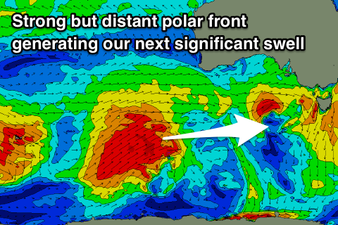
This will be produced by a strong polar low developing south-west of WA and projecting a fetch of W/SW gales through our far western swell window.
A long-period and inconsistent W/SW groundswell should arrive through Sunday and kick to a good 2ft+ across Clifton, easing from a similar size Monday morning.
Winds look favourable and offshore for both later Sunday and Monday. Beyond this the swell window will go quiet again until possibly later in the week, but more on this Wednesday.

