Fun clean swells early next week

Southern Tasmania Surf Forecast by Craig Brokensha (issued Friday 7th September)
Best Days: Monday, Tuesday, early Wednesday
Recap
Tiny waves the last couple of days, with a possible new increase in swell later today, if we're lucky.
Today’s Forecaster Notes are brought to you by Rip Curl
This weekend and next week (Sep 8 - 14)
The weekend is looking tiny to flat, with any increase in tiny size later today expected to ease back from 1ft tomorrow.
Later Sunday's swell from a distant and relatively weak polar front is still on the cards with 1-1.5ft sets likely before dark under a W/NW breeze.
A mix of better swells are on the cards for Monday, the first being an acute W'ly groundswell from a very strong storm firing up south-west of WA this evening.
 We'll see a fetch of severe-gale to storm-force W'ly winds projected through our western swell window, before dipping south-east away from us tomorrow evening and early Sunday.
This should provide inconsistent 2-3ft sets across Clifton during the afternoon when it peaks, but we're also due to see a small SW swell in the mix. This swell is expected to be generated by a small tight polar fetch of severe-gale W'ly winds this evening, producing 2ft waves Monday morning.
Winds for these swells look great with a persistent W/NW-NW breeze holding all day.
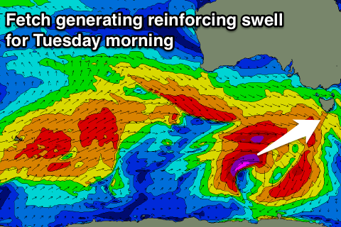
The easing trend will be slowed into Tuesday as another broader polar fetch of severe-gale W'ly winds develop south-west of us through the weekend.
2-3ft sets from the SW are due to persist on Tuesday morning, easing through the day and smaller into Wednesday and Thursday.
Winds will remain great and offshore from the N/NW Tuesday, with a W/NW change on Wednesday.
Longer term we've got a broad and strong polar frontal progression on the cards for mid-late week, generating swell late week/next weekend, but more on this Monday. Have a great weekend!