We've got a mix of easing east and new south swell tomorrow, smaller Friday.
Primary tabs
/reports/forecaster-notes/eastern-tasmania/2025/01/22/smaller-surf-the-end-the-week
Craig
Wednesday, 22 January 2025

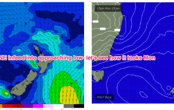
/reports/forecaster-notes/eastern-tasmania/2025/01/20/fun-east-swell-inbound
Craig
Monday, 20 January 2025
The current energy will be fun but easing tomorrow ahead of a better increase Wednesday.
/reports/forecaster-notes/eastern-tasmania/2025/01/17/fun-levels-east-swell-early-mid-next-week
Craig
Friday, 17 January 2025
The weekend looks generally small and weak with better surf due next week.
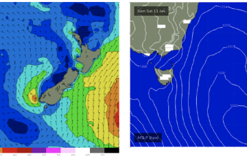
/reports/forecaster-notes/eastern-tasmania/2025/01/15/mix-south-east-and-east-swells-inbound
Craig
Wednesday, 15 January 2025
The coming days look small to tiny with some stronger E/SE to E swell next week.
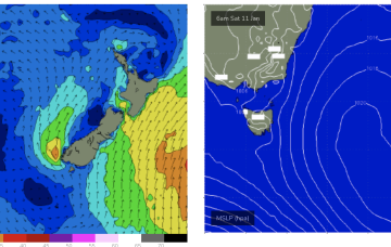
/reports/forecaster-notes/eastern-tasmania/2025/01/13/dynamic-sizey-period-likely
Craig
Monday, 13 January 2025
The coming period is quite dynamic with this week's north-east swells likely to be followed by larger east energy next week.
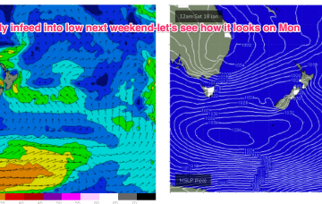
/reports/forecaster-notes/eastern-tasmania/2025/01/10/potential-very-dynamic-outlook-next-week-low
freeride76
Friday, 10 January 2025
This would see a new E’ly-E/NE’ly swell fill in Fri and reach large levels over the weekend with an E’ly fetch aimed straight at Tasmania.
/reports/forecaster-notes/eastern-tasmania/2025/01/08/another-round-workable-ne-windswell-peaking
freeride76
Wednesday, 8 January 2025
High pressure moves near the South Island and a broad inland low will see winds freshen from N-NE over the weekend, with NE windswell building.
/reports/forecaster-notes/eastern-tasmania/2025/01/06/quick-spike-in-s-swell-short-term-some-workable
freeride76
Monday, 6 January 2025
On the other side of the trough we revert back to N’ly winds and small NE windswells, becoming sizier into the weekend.
/reports/forecaster-notes/eastern-tasmania/2025/01/03/small-ne-windswell-ahead-some-juicy-prospects
freeride76
Friday, 3 January 2025
With high pressure moving NE into the Tasman we’ll see winds from the N freshen through Sat reaching mod/fresh paces in the a’noon. That should generate some workable NE windswell for tomorrow.
/reports/forecaster-notes/eastern-tasmania/2025/01/01/small-ne-windswells-developing-over-the-weekend
freeride76
Wednesday, 1 January 2025
Sat looks like more energy, as NE windswell builds in response to a strengthening N/NE flow as high pressure and an approaching trough combine.
