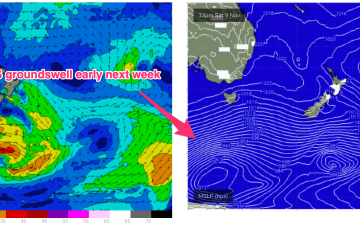
Sunday is looking very sizey indeed as the fetch ramps up with low end gales off the coast of Tasmania extending up towards Bass Strait and the Gippsland coast.
Primary tabs
/reports/forecaster-notes/eastern-tasmania/2024/11/13/sizey-ne-windswell-ahead-the-weekend
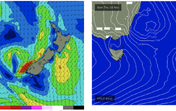
freeride76
Wednesday, 13 November 2024

/reports/forecaster-notes/eastern-tasmania/2024/11/11/small-blend-week-sizey-ne-windswell-the-weekend
freeride76
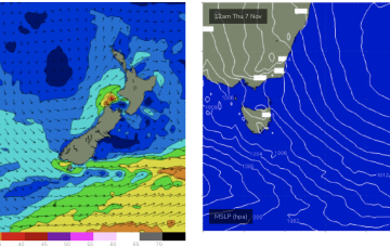
Monday, 11 November 2024
Another unstable, troughy week ahead with humid, unstable air over the continent creating a series of troughs, one of which forms a slow moving trough of low pressure off the Mid North Coast which interacts with a weak high pressure cell drifting in the Tasman. That will supply some workable E/NE quadrant swell along with more local E swell.
/reports/forecaster-notes/eastern-tasmania/2024/11/07/generally-small-some-s-swell-in-the-mix-and
freeride76
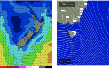
Friday, 8 November 2024
S’ly groundswell is currently being generated by a slow moving polar low on the far edge of the swell window well to the SW of Tasmania. Most of this swell is better aimed at the southern states and South Pacific targets but we will see some refraction into the East Coast of Tasmania
/reports/forecaster-notes/eastern-tasmania/2024/11/06/ne-windswells-continue-s-groundswell-pulse-in
freeride76
Wednesday, 6 November 2024
A powerful low below the continent this weekend promises a flukey south groundswell while we should see a notch more short period E/NE swell next week from a slow moving trough/low in the Tasman.

/reports/forecaster-notes/eastern-tasmania/2024/11/04/mix-ne-windswells-and-some-small-s-groundswell
freeride76
Monday, 4 November 2024
We’ll be relying on some small NE windswell episodes and great circle paths under the continent to deliver some flukey S groundswell short and medium term.
/reports/forecaster-notes/eastern-tasmania/2024/11/01/few-spikes-ne-windswell-ahead
freeride76
Friday, 1 November 2024
The freshening N-NE flow along the NSW temperate coast should generate some NE windswell through Wed PM, peaking Thurs
/reports/forecaster-notes/eastern-tasmania/2024/10/30/chunky-ne-windswell-sun-not-much-otherwise
freeride76
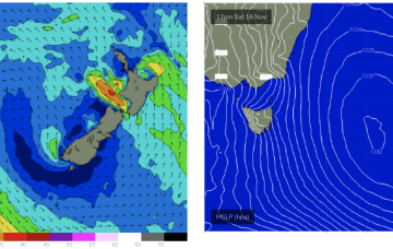
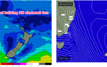
Wednesday, 30 October 2024
Some modest frontal activity pushes through late in the week with a developing N’ly flow on Sun set to provide some NE windswell.
/reports/forecaster-notes/eastern-tasmania/2024/10/28/small-surf-week-sizey-ne-swell-the-radar-sun
freeride76
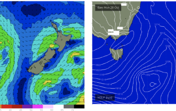
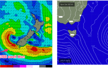
Monday, 28 October 2024
Under current modelling it looks one of the more significant NE fetches for the Spring, extending north into sub-tropical latitudes right down to Tasmania.
/reports/forecaster-notes/eastern-tasmania/2024/10/25/mostly-the-small-side-few-fun-options-ahead
freeride76
Friday, 25 October 2024
A complex but disjointed low has formed in the Tasman with diffuse centres off the North Coast and Tasmania/Gippsland coast. We’ll see S swells generated by the proximate fetches from this system easing into the weekend.
/reports/forecaster-notes/eastern-tasmania/2024/10/23/more-s-swell-fri-and-next-week
freeride76
Wednesday, 23 October 2024
That will see a S wind change and some, windy but sizey S swells through the end of the week into the weekend. Lingering troughiness in the Tasman may see yet another low form next week- which would be the 4th successive surface low to form in October.