No great change to the weekend f/cast. Low pressure has moved off the coast and is slow moving, with a broad fetch of strong E’ly winds on the southern flank of the low supplying plenty of E’ly swell to NE Tasmania.
Primary tabs
/reports/forecaster-notes/eastern-tasmania/2023/12/01/solid-easing-swells-over-the-weekend-not-much
freeride76
Friday, 1 December 2023
/reports/forecaster-notes/eastern-tasmania/2023/11/29/large-and-stormy-e-swells-ahoy-low-moves-far
freeride76
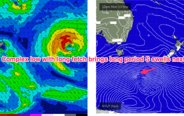
Wednesday, 29 November 2023
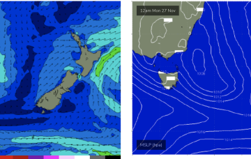
A dynamic weather event is underway as a complex inland low approaches the Far South Coast of NSW, expected to enter the Tasman Sea tomorrow. A moist NE-E/NE infeed into the low is generating plenty of rain (heaviest falls on the South Coast) and building swells from the same direction, focussed on NETas. We’ll see large surf develop across NETas as the low moves offshore tomorrow.
/reports/forecaster-notes/eastern-tasmania/2023/11/27/dynamic-week-large-stormy-swells-ahead
freeride76
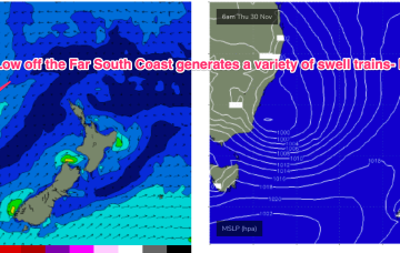
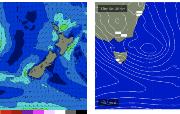
Monday, 27 November 2023
Most of the infeed into the system and resultant flow off the southern flank of the low is now focussed on Southern NSW and Tasmania (compared to Mondays notes). Large to XL swells this week are expected as the system forms and drifts south.

/reports/forecaster-notes/eastern-tasmania/2023/11/24/dynamic-pattern-head-large-windy-swells-sun
freeride76
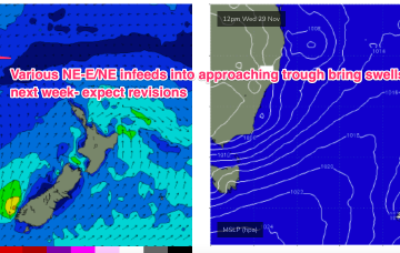
Friday, 24 November 2023
By Wed we should see another building trend as another trough deepens in Southern NSW/Gippsland and a strong infeed into the trough builds E/NE swells.
/reports/forecaster-notes/eastern-tasmania/2023/11/22/large-stormy-surf-forming-over-the-weekend
freeride76
Wednesday, 22 November 2023
That trough then deepens o/night Sat into Sun with a building trend in S-S/SE swell under fresh/strong winds from the same direction.
/reports/forecaster-notes/eastern-tasmania/2023/11/20/quiet-week-ahead-swell-sources-the-weekend
freeride76
Monday, 20 November 2023
Into the weekend and we should see an increase in NE-E/NE swell on Sat from winds feeding into a trough near the Gippsland coast.
/reports/forecaster-notes/eastern-tasmania/2023/11/17/strong-s-swell-sun-another-pulse-later-next
freeride76
Friday, 17 November 2023
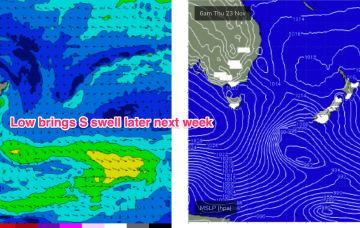
Sun is a different story as strong, long period S swells from a storm force system in the Southern Ocean make landfall.
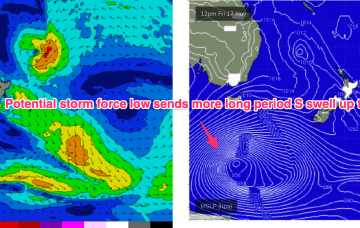
/reports/forecaster-notes/eastern-tasmania/2023/11/15/more-long-period-s-swell-ahead-sun
freeride76
Wednesday, 15 November 2023
Another deep low is expected to bomb under the continent and send more long period groundswell our way late this weekend under a continuing unstable, trough pattern.
/reports/forecaster-notes/eastern-tasmania/2023/11/13/strong-s-swell-pulses-ahead
freeride76
Monday, 13 November 2023
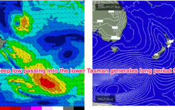
The continent is unstable with a heat trough over NWWA and more troughs extending from the interior through to the East Coast. A deep low and powerful frontal system with a long trailing fetch is currently traversing the lower Tasman, generating long period S swells.
/reports/forecaster-notes/eastern-tasmania/2023/11/10/strong-ne-windswell-peaks-sat-sly-swells-next
freeride76
Friday, 10 November 2023
No great change to the weekend f/cast. The N’ly fetch reaches peak strength o/night and into Sat morning with a corresponding peak in NE windswell expected.