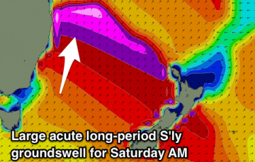
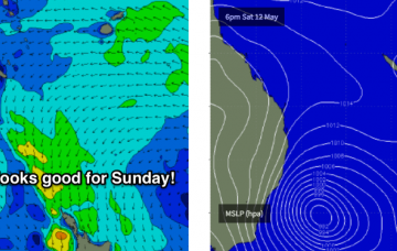
Mix of S'ly and S/SE swells tomorrow, clean and easing Friday with a large new long-period S'ly groundswell Saturday morning, easing into Sunday morning, with a fresh pulse for Monday morning and plenty more next week.
Primary tabs
/reports/forecaster-notes/south-east-queensland-northern-new-south-wales/2018/05/16/southerly-swell
Craig
Wednesday, 16 May 2018
/reports/forecaster-notes/south-east-queensland-northern-new-south-wales/2018/05/14/great-surf
Craig
Monday, 14 May 2018
Large S/SE groundswell pulse tomorrow morning, easing off into the afternoon, with a mix of smaller reinforcing S/SE and S swells through the end of the week. Strong new S'ly groundswell Saturday morning.
/reports/forecaster-notes/south-east-queensland-northern-new-south-wales/2018/05/11/acute-sly-swell
Craig
Friday, 11 May 2018
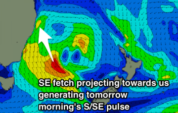
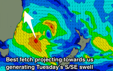
Small background swell tomorrow with a new acute S'ly swell Sunday south of Byron. Temporary drop in size Monday morning, with a better S/SE swell for Tuesday morning with workable winds in the morning.
/reports/forecaster-notes/south-east-queensland-northern-new-south-wales/2018/05/09/large-and-windy
thermalben
Wednesday, 9 May 2018
Sunday’s shaping up to deliver very large S’ly swells in Northern NSW though only protected locations will offer anything worthwhile.
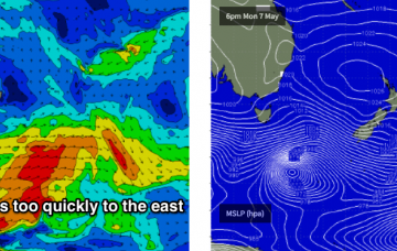
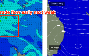
/reports/forecaster-notes/south-east-queensland-northern-new-south-wales/2018/05/07/plenty-swell-week
thermalben
Monday, 7 May 2018
Most mornings this week look fun across Northern NSW thanks to the east swell, and SE Qld is probably going to deliver the best waves Wednesday and Thursday.
/reports/forecaster-notes/south-east-queensland-northern-new-south-wales/2018/05/04/tricky-weekend
thermalben
Friday, 4 May 2018
The only window of opportunity for a dawn patrol Saturday morning will be along the Sunshine Coast.
/reports/forecaster-notes/south-east-queensland-northern-new-south-wales/2018/05/02/tricky-forecast
thermalben
Wednesday, 2 May 2018
A long range E’ly groundswell mentioned in Monday’s notes is still a possibility for Friday, generated by a deep sub tropical low well south of Tahiti over the weekend.
/reports/forecaster-notes/south-east-queensland-northern-new-south-wales/2018/04/30/flukey-swells
thermalben
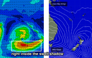
Monday, 30 April 2018
The only interruption to this is a possible long range E’ly swell from a deep subtropical low well east of New Zealand (and south of Tahiti) today.
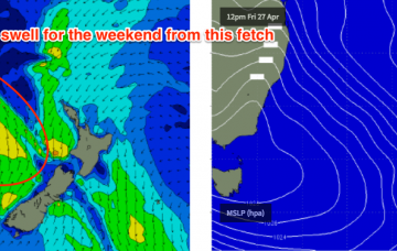
/reports/forecaster-notes/south-east-queensland-northern-new-south-wales/2018/04/27/strong-swells
thermalben
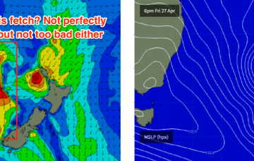
Friday, 27 April 2018
The current southerly change is interacting with a trough well south of New Caledonia, and is expected to broaden and deepen a low pressure system west of Auckland tonight, with a wide fetch of southerly gales on its western flank.
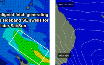
/reports/forecaster-notes/south-east-queensland-northern-new-south-wales/2018/04/25/small-beachies
thermalben
Wednesday, 25 April 2018
A strong ridge will develop through the Tasman Sea in the way of Friday’s gusty S’lies, and this will generate strong S/SE swells for the region this weekend.