Small beachies Thursday; extended period of surf for the points late Friday onwards

South-east Queensland and Northern NSW Surf Forecast by Ben Matson (issued Wednesday 25th April)
Best Days: Thurs: light winds (mainly north from Ballina; smaller window on the Mid North Coast) and a small peaky E'ly swell. Keep an eye out for a S'ly change. Fri afternoon onwards: strong S'ly tending S/SE swells with the best options across the outer points. Likely to be plenty of SE swell through most of next week too.
Recap: Tuesday delivered better than expected conditions, with gusty S’ly winds not quite eventuating; they remained light across SE Qld and mainly SW through almost W/SW at times across Northern NSW. Complex coastal troughs, eh? At the same time, a small E’ly swell built across the coast, providing lovely peaky waves across many open beaches. This swell has held into today with mainly light winds and fun peaky beachies.
Today’s Forecaster Notes are brought to you by Rip Curl
This week (Mar 26 - 27)
Make the most of Thursday. A gusty southerly change will push up the Northern NSW coast during the day, though it’s been slightly delayed in the latest model output, so we should see a reasonable window of OK conditions across the Mid North Coast. Most locations north from Ballina should see favourable winds for the better part of the day.
The current E’ly swell is expected to ebb and flow somewhere in the 2ft range, occasionally 2-3ft on the more favourable parts of the tide, so hit up a reliable swell magnet for the most size. Do keep an eye out for the southerly though, particularly in Northern NSW. I’ll update in the comments if it shows earlier than expected.
Friday looks a mess with gusty southerly winds and initially small though rapidly building S’ly windswells that’ll probably reach somewhere in the 4-6ft range at south facing beaches (south of Byron) by close of business. Not that you’d consider surfing these spots though. Only protected southern corners will offer any shelter on Friday, and they’ll be considerably smaller.
The best options will be across the SE Qld outer points, through the afternoon as the swell finally starts to muscle up - we should see size increase up into the 3ft+ range here by dusk though it’ll be smaller running through the protected points. Expect small surf early morning.
Otherwise, everywhere else looks too windy for surfing on Friday.
This weekend (May 28 - 29)
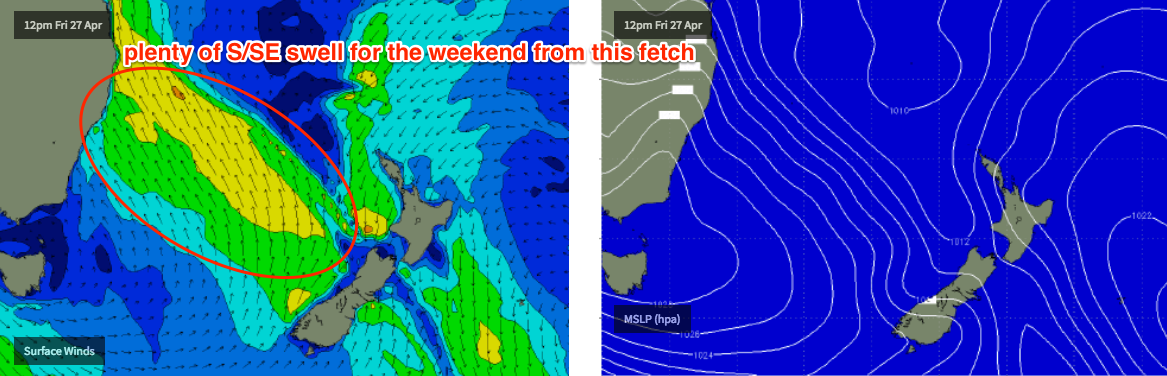
A strong ridge will develop through the Tasman Sea in the way of Friday’s gusty S’lies, and this will generate strong S/SE swells for the region this weekend.
At the same time, a new low pressure system will form off the west coast of New Zealand’s North Island, though we won’t see any swell from this particular fetch until early next week.
With the ridge holding firm all weekend, winds will locally remain gusty from the S/SE, which means protected points will have the only clean options. Exposed south facing beaches across Northern NSW should hold 5-6ft surf all weekend but it’ll tail off a little across the Mid North Coast into Sunday (being slightly out of the line of fire). However these spots will be a write off and you’ll have to aim for smaller options inside southern corners.
SE Qld will see plenty of surf all weekend but with these winds, the points will again be your best option (3-4ft outer points Saturday, easing a little Sunday). Keep in mind the strong southerly component in the swell direction too, as it’ll shave off a considerable amount of size for protected spots like Noosa.
So, there’s plenty of surf in store for the weekend, but unless you’ve got a good spot out of the wind, its going to be a rough ride.
Next week (Mar 30 onwards)
The developing low off New Zealand’s North Island should generate a fresh pulse for slightly longer period SE groundswell for Monday and Tuesday. At this stage I’m not terribly confident on the model output but a size range similar to what’s expected over the weekend seems quite plausible.
However, a new high in the Tasman Sea is expected to restrengthen SE winds across the coast which may once again confine the best surf prospects to the protected points. The upside of this ridge is that it’ll keep the coast flush with swell probably right through until the end of the week.
So, it’s an active forecast period ahead - just gotta work around the winds. See you Friday!
Comments
Hey, I have a Christmas present to cash in, trip to the Goldy, and could possibly come Wednesday-Friday next week. What are the prospects of some waves around Snapper?
There'll be waves, but it ain't worthy of cashing in your chips. Save it for a better swell.
Thanks for that.
Winds went S'ly in Coffs around 10am but are still generally under 10kts at the airport - though there's a few whitecaps visible on the surfcams. Doesn't seem to be too strong though.
The S'ly reached Byron an hour or two afterwards, and it's a little stronger - 12kts gusting 15kts - though Cape Byron's elevation exaggerated speeds so it's unlikely to be affecting surf much.. yet.
Do u reckon it will get big enough for Noosa Points over the weekend?
Cheers.
On a minor SE swell? No chance.